
Brzyna on the Dunajec: Routes and History
Accommodation in Brzyna
Brzyna combines its location on the Dunajec and along the Brzynka stream with described hiking and cycling routes and a history dating back to the 13th century. The routes and historical connections to the area offer different ways to get to know the character of the place as you plan your trip.
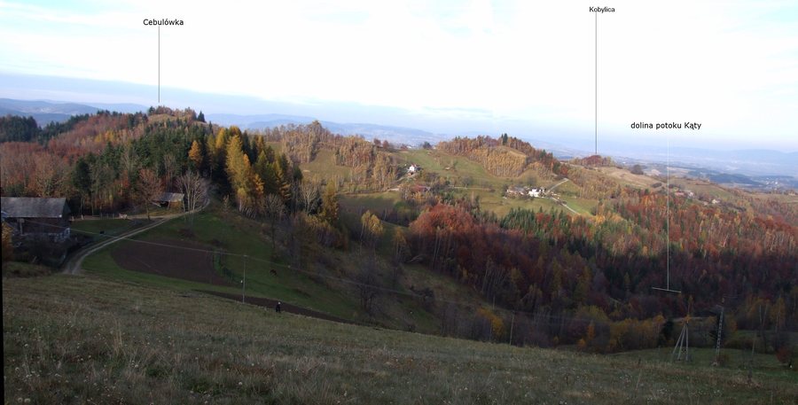
Brzyna at a glance
- Brzyna is in the Beskid Sądecki on the right bank of the Dunajec; Jazowsko lies opposite.
- The village stretches along the Brzynka stream.
- The yellow-marked hiking trail from Łącko to Dzwonkówka runs along the upper edge of Brzyna.
- A blue cycling route runs eight kilometers from Brzyna to Jazowsko.
- A red-marked cycling route runs 14 kilometers from Zarzecze through Brzyna to Jazowsko.
What kind of landscape defines Brzyna?
The location can be described in relation to two waterways and their spatial relationship: Brzyna stretches along the Brzynka and lies on the right bank of the Dunajec. Jazowsko lies on the opposite side of the Dunajec. This helps place the village in the Beskid Sądecki without treating the two settlements as one place.
The hiking trail also provides a specific connection to the surrounding area. Its described route runs from Łącko to Dzwonkówka and passes along the upper edge of Brzyna. From there, there are views of the Sądecka Basin, the Gorce Mountains, and the Beskid Wyspowy. This trail therefore connects the edge of the village with views of several named landscape areas. If you include Brzyna in your travel plans for its location and viewpoints, you can make this route a focus of your visit.
Which cycling route suits your plans?
The two described cycling routes differ in length, marker color, and course. The eight-kilometer blue-marked route starts in Brzyna and runs through Lipówki, Kretówki, Podwilcze, Obidza, and Opalanka to Jazowsko. The 14-kilometer red-marked route starts in Zarzecze, runs through Łąckie Wyrobiska, Jaworzynka, and Cebulówka, passes through Brzyna, and also ends in Jazowsko.
If you want to start your exploration in Brzyna, the blue route is the one that begins there. The red route, by contrast, passes through the village and covers a longer described distance. You can first choose between them based on their starting point, course, and stated distance. Both descriptions help distinguish the routes; the named places also show how their courses differ. The marker colors provide another simple way to tell the two routes apart.
What history does Brzyna tell?
In the 13th century, the defensive castle of Lemiesz stood above the hamlet of Misiołówka, at the confluence of the Dunajec and the Obidza stream. It made it harder to cross the Radziejowa Ridge from the south and secured the descent into the Jazowska Valley. The castle is also credited with guarding a mountain trade route from Hungary to Poland. Taken together, these details show the site’s importance at the time for both defense and trade.
Its location at the confluence and the functions attributed to it provide a specific historical connection to Brzyna and its surroundings. This is about the castle’s role in the past: its history is linked to the route over the ridge and the way into the Jazowska Valley. Those interested in the historical context of the Beskid Sądecki will find a clearly identified point of reference here, without confusing the castle’s medieval function with present-day visitor facilities.
Discover more destinations: Zawadka, Labowa, Białawoda, Binczarowa, Wierchomla Wielka, Krynica-Zdrój, Krzyżówka, Uhryń.
FAQ
What views does the hiking trail near Brzyna offer?
The yellow-marked hiking trail from Łącko to Dzwonkówka runs along the upper edge of Brzyna and offers views of the Sądecka Basin, the Gorce Mountains, and the Beskid Wyspowy.
Which cycling route starts in Brzyna?
The eight-kilometer blue-marked route starts in Brzyna and runs through several named places to Jazowsko. The 14-kilometer red-marked route passes through Brzyna but starts in Zarzecze.
What role did Lemiesz Castle play?
The castle stood in the 13th century above Misiołówka, at the confluence of the Dunajec and the Obidza stream. It made it harder to cross the Radziejowa Ridge from the south, secured the descent into the Jazowska Valley, and guarded a mountain trade route from Hungary to Poland.
For the broader travel overview: Nowy Sącz.

