
Łężeczki by Lake Chrzypskie
Accommodation in Łężeczki
Łężeczki combines its location by Lake Chrzypskie with a viewpoint and several described routes. When planning, it is worth distinguishing the walking route from the two cycling routes: they differ in their courses and destinations.
Łężeczki at a glance
- Łężeczki is a village by Lake Chrzypskie in Sierakowski Landscape Park.
- A 7.7-kilometer walking trail starts in the village.
- An 8.5-kilometer cycling loop runs around the lake and through Łężeczki.
What characterizes the location by Lake Chrzypskie?
Lake Chrzypskie covers 322 hectares, is 11 meters deep, 3 kilometers long, and 2.2 kilometers wide. These measurements can vary depending on the measurement method and water level. They describe different dimensions of the lake; the lengths of the walking and cycling routes should be considered separately. The village lies by the lake and also within Sierakowski Landscape Park. Together, these features define the setting for the routes described, each of which has its own waypoints and destination.
What can you see at the viewpoint?
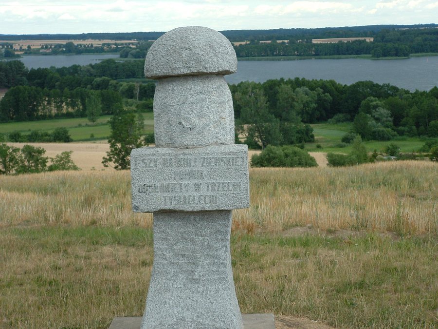
A mushroom-shaped monument stands at the Łężeczki viewpoint. It was unveiled in the first few minutes of the new millennium. The viewpoint is also a useful landmark for route planning: the black R-8 cycling route passes by it, and the cycling loop around Lake Chrzypskie runs via the “Grzyb” viewpoint in Łężeczki. This makes it possible to associate this distinctive place with both the monument and two cycling routes described in different ways.
Which walking and cycling routes pass through Łężeczki?
The walking trail starts in Łężeczki and is 7.7 kilometers long. It runs via Chrzypsko Małe and Lake Liśnia to its junction with the yellow walking trail. These waypoints help distinguish the route from the cycling options. Check local trail conditions before setting out.
Two cycling routes are listed. The black R-8 cycling route runs from Międzychód to Szamotuły through Łężeczki and past the viewpoint. Check its markings locally. The 8.5-kilometer loop around Lake Chrzypskie runs via Chrzypsko Wielkie, a railway viaduct, Chrzypsko Małe, and the “Grzyb” viewpoint in Łężeczki, before returning to Chrzypsko Wielkie. This means a route described as a loop is presented alongside a route with the named endpoints Międzychód and Szamotuły. For the loop as well, check local trail conditions before setting off.
Discover more destinations: Bucharzewo, Kwilcz, Śródka, Tuchola, Chrzypsko Wielkie, Gorzyń, Kamionna, Sieraków.
FAQ
Which walking route starts in Łężeczki?
A 7.7-kilometer walking trail starts in the village and runs via Chrzypsko Małe and Lake Liśnia to its junction with the yellow walking trail.
How do the two cycling routes differ?
The black R-8 runs from Międzychód to Szamotuły through Łężeczki. The 8.5-kilometer loop around the lake returns to Chrzypsko Wielkie.
What are the dimensions of Lake Chrzypskie?
Lake Chrzypskie covers 322 hectares, is 11 meters deep, 3 kilometers long, and 2.2 kilometers wide. The measurements can vary depending on the measurement method and water level.
Go to the main travel overview: Birnbaum.

