
Sromowce Wyżne
Accommodation in Sromowce Wyżne
Sromowce Wyżne is an interesting starting point for travelers who want to combine a rafting trip through the Dunajec Gorge with insights into the Pieniny Mountains and the history of the village. A hike to Sołtysia Skała or Macelak may also be important when planning your trip.
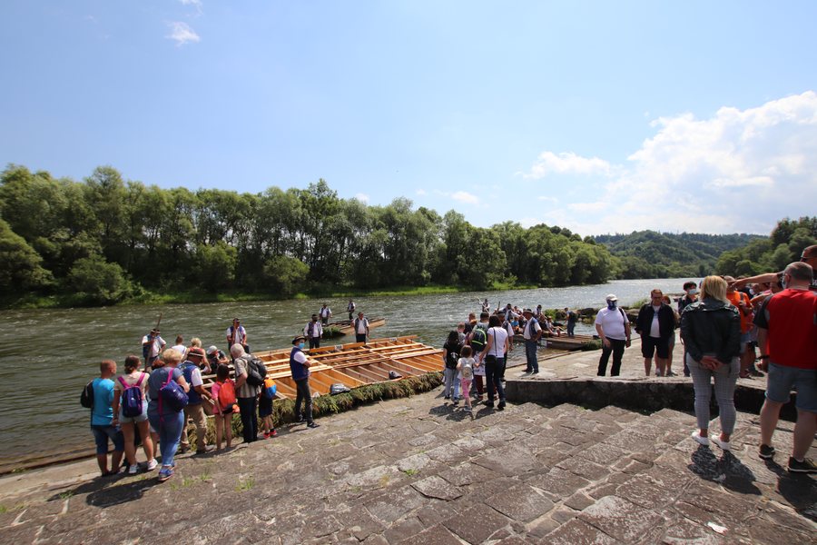 File:Sromowce Wyzne przystan flisacka 1.jpg
Photo: Andrzej Otrębski via Wikimedia Commons, CC BY-SA 4.0
File:Sromowce Wyzne przystan flisacka 1.jpg
Photo: Andrzej Otrębski via Wikimedia Commons, CC BY-SA 4.0
Quick facts about Sromowce Wyżne
- The hamlet of Kąty in Sromowce Wyżne is the departure point for the Dunajec River rafting trip run by the Polish Pieniny Rafting Association.
- In Kąty, the exhibition pavilion of Pieniński Park Narodowy features an exhibition on the nature and conservation of the Pieniny Mountains, as well as the region’s history and traditions. Admission is free.
- The hiking route from Sromowce Wyżne to Macelak is 5.6 km long and has a total elevation gain of 490 metres.
- The Stations of the Cross route to Sołtysia Skała has more than 150 gravel and wooden steps.
What experiences define a stay here?
The Dunajec River rafting trip begins at the departure point in the hamlet of Kąty. It is run by the Polish Pieniny Rafting Association and travels through the Dunajec Gorge. If this experience is a key part of your trip, you can consider Sromowce Wyżne as a starting point. The specific departure point is Kąty, within the village.
The exhibition pavilion of Pieniński Park Narodowy in Kąty offers a different perspective on the region. The exhibition covers both the nature of the Pieniny Mountains and its conservation, as well as the region’s history and traditions. Admission is free. This lets you explore regional culture and the past alongside a nature-focused topic, without having to budget for admission to the pavilion.
What should you keep in mind when hiking?
The Stations of the Cross route to Sołtysia Skała in the Kalwaria of Sromowce Wyżne has more than 150 gravel and wooden steps. They wind through the forest in seven switchbacks. The number and type of steps give the route a distinctly different character from a hike described primarily by its distance. If you plan your day around the type of route, this specific layout is a factor to consider.
From the final stations of the Kalwaria, you can see the Pieniny Mountains, Magura Spiska, the Spisko-Gubałowskie Foothills, and the Tatras. The Stations of the Cross route therefore combines a series of stations with views of several mountain landscapes. This may interest you if you want to consider not only the route itself but also the views from its final stations.
The hiking route from Sromowce Wyżne to Macelak is listed as 5.6 km long, with a total elevation gain of 490 metres and separate times for the outward and return journeys: the outward journey takes 2 hours and 15 minutes, and the return takes 1 hour and 45 minutes. You can consider the distance, elevation gain, and times together to assess whether this hike suits your planned hiking day.
What history and culture can you discover in the village?
Sromowce Wyżne was originally called Przekop. The village was first documented in 1323, as the first village founded by the Poor Clares under Magdeburg rights. This early record gives the village a specific historical connection; it describes its history, not the present-day use of individual buildings.
The brick Church of St. Stanislaus was built in 1875. A Podhale dialect is also spoken in Sromowce Wyżne, with strong Slovak, Hungarian, and Romanian influences. The church, the village’s history, and its dialect offer different ways to explore local culture: through a building, historical development, and the spoken language.
FAQ
Where does the Dunajec River rafting trip begin?
The departure point is in the hamlet of Kąty in Sromowce Wyżne. The Polish Pieniny Rafting Association’s trip through the Dunajec Gorge starts there.
Is admission to the exhibition pavilion free?
Yes. Admission to the exhibition pavilion of Pieniński Park Narodowy in Kąty is free.
How long is the hiking route to Macelak?
The route from Sromowce Wyżne to Macelak is 5.6 km long and has a total elevation gain of 490 metres. The outward journey is listed as taking 2 hours and 15 minutes, and the return journey 1 hour and 45 minutes.
Back to the main travel overview: Lesser Poland.

