
Dugi Otok: Nature Park, Cliffs and Sakarun
Accommodation in Dugi Otok
Dugi Otok combines a nature park, a striking coastline and a beach. Telašćica is in the south of the island, while Sakarun is on its northwest coast. To plan your trip, you can first consider whether you want to focus on walks and views, water activities or a beach visit.
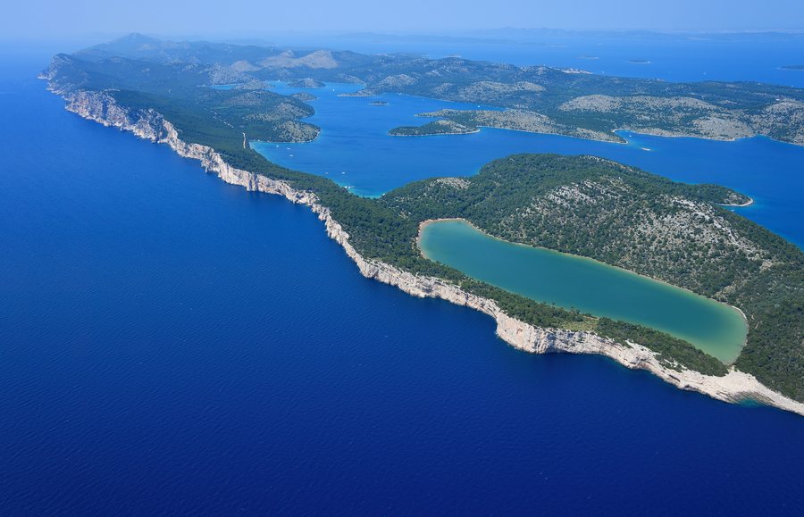 File:Aerial image of Telašćica Nature Park (view from the south).jpg
Photo: Carsten Steger via Wikimedia Commons, CC BY-SA 4.0
Dugi Otok facts at a glance
- Telašćica Nature Park covers a total of 70.50 km², including 25.95 km² of land and islets and 44.55 km² of sea.
- The cliffs of Dugi Otok rise up to 161 m above the sea and extend up to 90 m below it.
- Sakarun Beach is about 300 m long; the swimming area is spacious and shallow.
- Dugi Otok is a starting point for excursions to Telašćica Nature Park and Kornati National Park.
What makes Telašćica and the cliffs distinctive?
The nature park includes the southern part of Dugi Otok, its associated islets and part of the sea area of Zadar County. The breakdown of its 70.50 km² highlights the different areas: 25.95 km² consist of Dugi Otok and the nearby islets, while 44.55 km² are sea. Telašćica is therefore described not only as a land area, but also includes a large sea area.
The cliffs of Dugi Otok are also known as “stene.” The nature park gives their height as up to 161 m above the sea; at the same time, they extend up to 90 m below the sea surface. These two measurements describe the cliffs above and below the water, conveying their vertical extent.
What experiences does the nature park offer?
In the nature park, you can walk to interesting places and enjoy the view from the Grpašćak viewpoint. Diving is possible at several attractive spots near the cliffs. If you want to balance time on land with activities on the water, the park’s range of activities offers several options.
These include organized nature tours, boat trips, water sports, diving, fishing, cycling and photo safaris. These activities offer different focuses: a nature tour or photo safari centers on experiencing nature, while boat trips and water sports put the water in the foreground. This list describes the park’s activities but does not specify dates or availability.
What should you know about Sakarun Beach?
Sakarun is on the northwest coast of Dugi Otok. Veli Rat, Veruni, Soline and Božava are near the beach; pine trees provide shade there in summer. The beach is approximately 300 m long. This should be distinguished from the water-depth figure: about 250 m from shore, the water is 3.5 m deep. The swimming area itself is described as spacious and shallow.
For your planning, these details help distinguish the beach’s length, water depth and the character of the swimming area. The shade from the pine trees in summer is an additional feature of the beach surroundings.
Which excursions and interests can you compare?
Excursions from Dugi Otok go to Telašćica Nature Park and Kornati National Park. On the island itself, you can consider the park’s activities, the Grpašćak viewpoint and Sakarun Beach as different interests when planning your trip.
If you’d like to broaden your travel ideas, explore: Cres, Lika-Senj, Požega-Slavonia County, Krk, Korcula, Međimurje County, Murter and Sisak-Moslavina County.
FAQ
How large is Telašćica Nature Park?
The nature park covers a total of 70.50 km²: 25.95 km² on Dugi Otok and the neighboring islets, plus 44.55 km² of sea.
Can you dive near the cliffs in the nature park?
Yes. Diving is possible at several attractive spots near the cliffs.
How long is Sakarun Beach?
Sakarun is about 300 m long. About 250 m from shore, the water is 3.5 m deep; the swimming area is spacious and shallow.
For the main travel overview: Croatia.

