
Tornaszentandrás: Cultural History and Karst Landscape
Accommodation in Tornaszentandrás
Tornaszentandrás can be viewed through two themes: cultural history and karst landscape. Both perspectives become tangible through named buildings, geological features and routes. The themes can be compared by date, scale, spatial extent and type of activity.
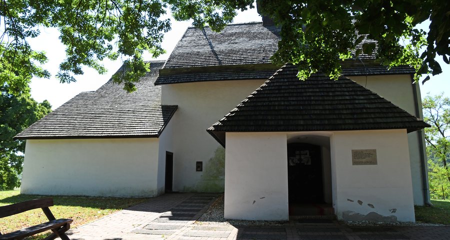 Roman Catholic church in Tornaszentandrás
Photo: Pasztilla aka Attila Terbócs via Wikimedia Commons, CC BY-SA 4.0
Roman Catholic church in Tornaszentandrás
Photo: Pasztilla aka Attila Terbócs via Wikimedia Commons, CC BY-SA 4.0
Culture and History
The Szent András parish church dates from the 12th century; its first written mention dates to 1283. The Szladics féle heritage house is located in a building originally constructed in 1918. It was restored with a new roof and renewed interior and exterior plaster. The memorial room in the Szladics féle heritage house is furnished with furniture and household objects belonging to the founding family. The rear room provides space for temporary exhibitions and other events. For a thematic comparison, you can consider the religious building, the history of the house and the event space separately. The exhibition activity of the rear room thus differs from the described furnishings of the memorial room. The building, house and room function can therefore be classified separately.
Nature and Landscape
The Rákóczi 1. sz. cave is notable for the richness and variety of its stalactite and mineral formations, particularly its various types of cave pearls and helictites. It lies in the Szalonnai Karst, on the VIIth mining level of Mount Esztramos. According to current surveys, it extends approximately 70 metres horizontally, is 750 metres long in total and extends 79 metres vertically. A lake is located at the bottom of each of the two main fracture zones.
For chronological context, it is important to note that Rákóczi Cave was closed on 16 February 2026 for renovation work and is expected to remain inaccessible for at least two years.
The Szár-hegy, Tegarn and Verő-tető mountains are located in the vicinity of Tornaszentandrás. In the wider regional area are the Svätý Ladislav ruins, Nagy-oldal mountain and Svätá Anna Church. Qualitative features and measurable extents represent different levels of information; for your planning, you can read the natural feature, spatial location and extent separately.
Hiking and Climbing
The Bódvarákó–Tornaszentandrás–Esztramos-hegy–Bódvarákó route is a moderately difficult 10-kilometre circular hike with 220 metres of elevation gain and an estimated duration of 2.5 hours. Seven via ferrata routes have been established on Mount Esztramos. The hike and the via ferrata routes represent different types of activity. For your planning, you can compare the route length, elevation gain, estimated time and number of routes separately. Hiking and via ferrata can be considered separately as different types of activity. The figures for the circular tour describe the distance, ascent and time required; the seven via ferrata routes, on the other hand, state a number. The two sets of information therefore remain separate as different characteristics of the activity description.
For a hotel in Tornaszentandrás, travel dates, room category and cancellation conditions can be read as separate comparison points on booking pages. The travel dates indicate the intended period, the room category the selected form of accommodation, and the cancellation conditions a separate item of information. Thus, these three details stand alongside one another, each with its own function.
Other places in the same overarching area are Komjáti, Aggtelek, Debréte, Szuhogy, Szendrő, Bódvarákó, Viszló and Perkupa.
For the overarching travel overview: Edelényi.

