
Gierczyce: War Cemetery and Local History
Accommodation in Gierczyce
Military Cemetery No. 336, Czyżyczka Hill and the history of the Parish of Our Lady of Sorrows give Gierczyce three clearly distinct points of interest. For planning your trip, they bring together remembrance of the First World War, landscape and local architectural history.
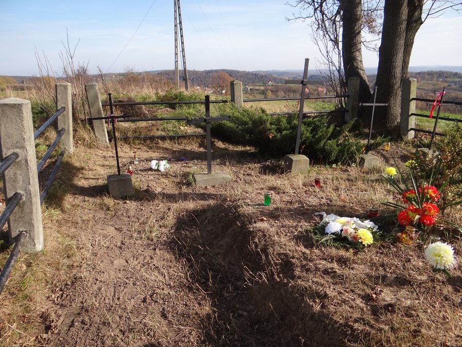 File:Cmentarz wojenny nr 336 - Gierczyce-Czyżyczka 4.jpg
Photo: Jerzy Opioła via Wikimedia Commons, CC BY-SA 3.0
Gierczyce at a glance
The military cemetery is located at the summit of the 364-metre-high Czyżyczka Hill in Gierczyce, in the Bochnia municipality. Czyżyczka is a viewpoint with a panorama to the south across the Wieliczka and Wiśnicz Foothills, with the Beskids rising beyond them. The Parish of Our Lady of Sorrows is located at Gierczyce 10, 32-744 Gierczyce.
What does Military Cemetery No. 336 tell us?
Soldiers of the Austro-Hungarian and Russian armies who fell in 1914 during the Limanowa–Łapanów Operation are buried at the military cemetery. The cemetery was established in 1915–1916 to a design by Franz Stark and is listed under register number A-100/M, dated 28 June 2007. The dates mark different stages: the deaths in 1914, the cemetery’s establishment in 1915–1916 and its register entry in 2007. This makes it possible to distinguish the creation of the memorial site from the events it commemorates.
How can the hill be understood in context?
The viewpoint opens up a view to the south across the Wieliczka and Wiśnicz Foothills towards the Beskids rising beyond them. The panorama therefore describes more than a single summit: it connects the foreground landscape with the Beskids visible farther away. For directions to the cemetery, one route description mentions a turn between buildings onto a path leading towards a water reservoir. The cemetery is about 200 metres from the Gierczyce–Nieprześnia road. The description is based on a signpost at the roadside from 2017 and serves as a guide, not as a guarantee of current access.
What traces of the parish’s history remain?
The temporary chapel of the Parish of Our Lady of Sorrows was created by converting a manor house dating from around 1880. Czesław Gajek bought the house in 1972. The church interior also contains 19th-century paintings transferred from the chapel previously in use. This sequence brings together an older manor house, its later purchase and the development of a chapel. Alongside the history of the military cemetery associated with 1914–1916, it represents another layer of local architectural and religious history.
Which regional route is associated with Gierczyce?
A regional publication from 2012 lists Gierczyce as one of the seven sołectwa (village administrative units) in the Bochnia municipality included in the Małopolska Fruit Trail. This reference adds a connection to a regional fruit-growing route to the local history and landscape themes. If you plan to rely on signs today, check their current status in advance.
Discover more destinations: Bochnia, Lipnica Górna, Rzezawa, Grobla, Lipnica Murowana, Zawada, Rozdziele and Rajbrot.
FAQ
Which armies are buried at the military cemetery?
Soldiers of the Austro-Hungarian and Russian armies who fell in 1914 during the Limanowa–Łapanów Operation are buried there.
How is the route to the cemetery described?
The route description mentions a turn between buildings onto a path leading towards a water reservoir; the cemetery is about 200 metres from the Gierczyce–Nieprześnia road. The signpost described dates from 2017, so this information is a guide, not a guarantee of current access.
What was the temporary chapel converted from?
It was created by converting a manor house dating from around 1880, which Czesław Gajek bought in 1972.
For the broader travel overview: Bochnia.

