
Gajków: Baroque Church, Hillfort and Cycling Route
Accommodation in Gajków
Gajków combines a rural Baroque church with prehistoric traces and a nearby hillfort. A cycling route runs from Gajków to the bridge in Kamieniec Wrocławski and continues towards the Oder.
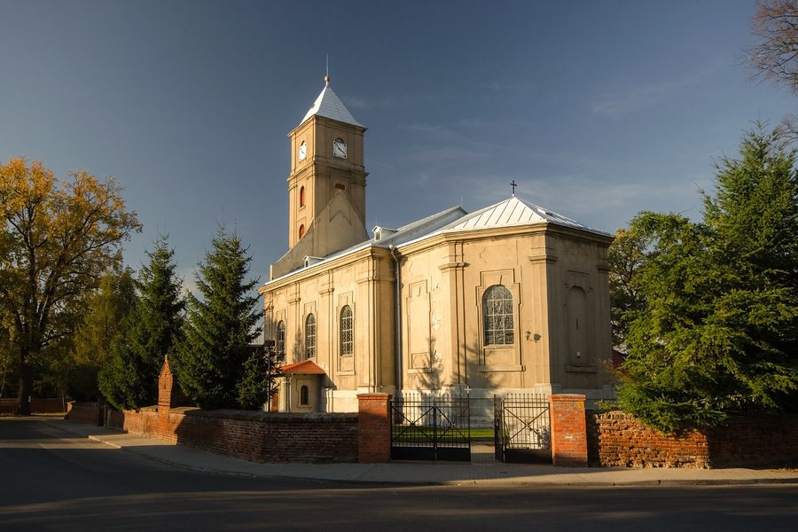 File:SM Gajków Kościół św Małgorzaty (2) ID 599531.jpg
Photo: Sławomir Milejski via Source, CC BY-SA 3.0 pl
Key facts about Gajków
- The parish church of St Margaret is a rural Baroque church built by master mason Jacob Straube at the instigation of Ignatius Magnet.
- The oldest settlement traces in the area date back more than 6,000 years and are attributed to the Komornica hunter-gatherer culture.
- The hillfort lies around 200 metres beyond the southern edge of the village; what remains is a square mound with a ditch and rampart.
- The cycling route follows Kanałowa Street and the embankments along the Kanał Janowicki to the bridge in Kamieniec Wrocławski.
What stories do the church and finds tell?
The timespan is wide: the oldest settlement traces date back more than 6,000 years and are attributed to the Komornica hunter-gatherer culture. Sharp-edged tools found by the Oder near Gajków were used for hunting in the surrounding forests and for fishing. Thus, evidence of early settlement sits alongside specific evidence of hunting and fishing.
The parish church of St Margaret belongs to a much later period. Master mason Jacob Straube built the rural Baroque church at the instigation of Ignatius Magnet, a master of the Breslau Knights of the Cross with the Red Star. Its furnishings are predominantly Baroque and date from around 1716; they include side altars, a pulpit and a baptismal font. If you are interested in cultural history, you can shift your focus between prehistoric traces and church architecture.
Where is the hillfort located in the surrounding area?
The hillfort lies around 200 metres beyond the southern edge of the village. What remains is a square mound surrounded by a ditch and rampart. It is interpreted as the remains of a late medieval fortified manor with timber-and-clay buildings. A fortified manor was a fortified farmstead; identifying the hillfort as such a site remains a historical interpretation.
Its location adds to the picture: the hillfort is at the foot of a plateau that slopes down towards the Oder valley, between the right bank of the Oder and a canal. This connects the historical subject with the landscape described between plateau, river and canal.
What themes came together on a walk in 2023?
During a walk in the area around Gajków in 2023, participants saw the remains of a stage at the site of a former boat landing. A guide introduced them to the history of the hillfort and read aloud legends about the site that he had translated. During the walk, participants also talked about a tree-lined avenue and its significance. The history of the Oder meanders, as well as the fish and plants found there, were also topics on the walk. Participants also noticed visible signs of beaver activity.
What is the cycling route from Gajków like?
The cycling route runs from Główna Street in Gajków via Kanałowa Street and along the embankments of the Kanał Janowicki to the bridge in Kamieniec Wrocławski. The section from Gajków ends there. Further on, a field path behind the bridge turns slightly right towards the Oder and then follows the river to Lake Bajkał.
If you include cycling in your travel plans, you can distinguish the section up to the bridge from the continuation along the river: the bridge is in Kamieniec Wrocławski, while Lake Bajkał comes later. The streets, embankments and crossings mentioned give the route a clear sequence, without making both sections into a single destination.
Discover more destinations: Wrocław, Brzezia Łąka, Wojnowice, Długołęka, Sulistrowice, Kiełczów, Chrząstawa Mała, Sokolniki.
FAQ
How old are the oldest settlement traces in Gajków?
They date back more than 6,000 years and are attributed to the Komornica hunter-gatherer culture.
What remains of the hillfort?
A square mound surrounded by a ditch and rampart. It is interpreted as the remains of a late medieval fortified manor with timber-and-clay buildings.
How does the cycling route continue after the bridge?
Behind the bridge in Kamieniec Wrocławski, a field path turns slightly right towards the Oder; the route then follows the river to Lake Bajkał.
Go to the main travel overview: Wroclaw.

