
Dąbrowa Górnicza: Lakes, Nature and Culture
Accommodation in Dąbrowa Górnicza
Dąbrowa Górnicza combines lakes and wetlands with traces of regional industrial history. This gives you a choice of different focuses when planning your trip: water activities, marked trails, wildlife watching and culture.
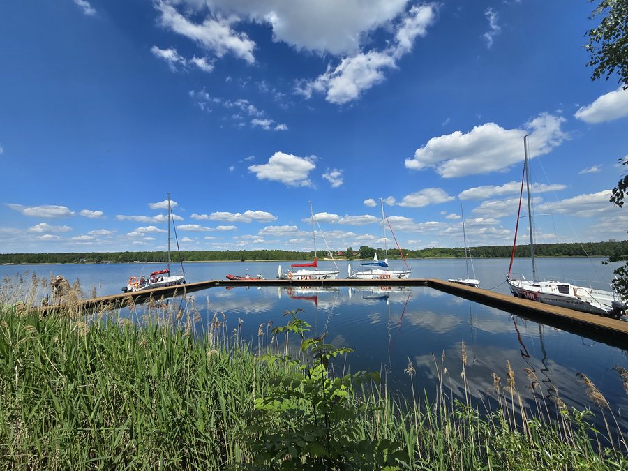 Pogoria I reservoir in Dąbrowa Górnicza, Silesian Voivodeship, Poland, May 2025
Photo: MichalPL via Wikimedia Commons, CC0
Pogoria I reservoir in Dąbrowa Górnicza, Silesian Voivodeship, Poland, May 2025
Photo: MichalPL via Wikimedia Commons, CC0
Dąbrowa Górnicza at a glance
The four Pogoria lakes are used for tourism and recreation; sailing and windsurfing are possible at Pogoria III. Trails lead to lakes, dunes and historic sites. Muzeum Sztygarka is dedicated to archaeological finds, industrial history and local ethnography.
What do the Pogoria lakes and the landscape offer?
Each lake offers something different. Marked cycling paths and routes run around each of the four Pogoria lakes and are also suitable for younger children. Pogoria III is also suitable for sailing and windsurfing. So if you choose the lake district primarily for recreation and leisure, you will find both cycling paths and water sports here.
The green-marked Szlak XXV-lecia leads to the waters of Pogoria II and Pogoria III and runs for approximately 18.5 km within Dąbrowa Górnicza. The approximate route length is a concrete reference point for planning your day, without indicating how long it takes to walk or cycle. In the area of one of the Pogoria II lakes, 84 vertebrate species are found; 52 of them are strictly protected. The area is therefore also of interest to visitors who want to combine time by the water with an appreciation of wildlife.
Park Zielona offers another glimpse of the area’s greenery: its 67 hectares contain the largest concentration of oak trees in the Dąbrowa Basin. Wzgórze Gołonoskie is legally protected as a natural and landscape complex. These places add parks and protected areas to the impression of a lake landscape.
Which trails lead through the surrounding area?
Several marked routes offer a choice of different distances. The red-marked Szlak Metalurgów is 13 km long and leads to the historic church on Wzgórze Gołonoskie, former quarries, an old lime kiln and sites of former clay pits. Along this route, you can see both historic buildings and traces of earlier extraction and processing. The quarries and clay pits mentioned are former sites of use; the route leads to their locations.
The yellow-marked Szlak Pustynny PTTK is longer, at 28.5 km: it starts in Błędów and crosses the Błędów Desert area from Mount Jałowce to Ryczów. Since the trails differ in their destinations and lengths, you can plan according to whether lakes, historic sites or the dune landscape are your priority.
A network of boardwalks runs through the marshes, allowing you to reach otherwise inaccessible places. The “Bagna w Antoniowie” ecological and educational trail has also opened.
Where can you encounter history and regional culture?
Muzeum Sztygarka displays archaeological finds from the early medieval production settlement in Łośniu, where lead and silver were smelted. The museum also presents the region’s industrial history and traditions, as well as the daily lives of miners and steelworkers. If you are interested in the development of work and production, you can include these topics in your trip alongside the area’s natural attractions.
A dedicated local ethnography section explores the folk culture, folklore and customs of the Dąbrowa Basin. Its focus differs from that of the archaeological finds and industrial history: here, cultural traditions and customs take center stage.
The Kościół Narodzenia Najświętszej Marii Panny i św. Antoniego in Gołonóg is also one of the city’s historic sites. The church was founded in 1675. The Szlak Metalurgów leads to this historic church on Wzgórze Gołonoskie and, in its route description, connects it with sites of former quarrying and clay extraction.
What makes the Błędów Desert special?
A considerable part of the Błędów Desert, also known as the “Polish Sahara,” lies within Dąbrowa Górnicza. It forms Central Europe’s largest complex of inland dunes. This makes its landscape markedly different from the Pogoria lakes and parkland. If you choose your destination based on landscape types, the city and its surroundings offer both lakes and wetlands as well as inland dunes.
FAQ
How long is the Szlak XXV-lecia in Dąbrowa Górnicza?
The green-marked trail runs for approximately 18.5 km within the city and leads to the waters of Pogoria II and Pogoria III.
What activities are possible at Pogoria III?
Pogoria III is suitable for sailing and windsurfing. Marked cycling paths and routes also run around each of the four Pogoria lakes.
What topics does Muzeum Sztygarka cover?
The museum displays archaeological finds from the early medieval production settlement in Łośniu and explores industrial history, regional traditions and local ethnography.
How long is the Szlak Metalurgów?
The red-marked Szlak Metalurgów is 13 km long. Among other places, it leads to the historic church on Wzgórze Gołonoskie and to former quarries.
Where does the Szlak Pustynny PTTK begin?
The yellow-marked Szlak Pustynny PTTK is 28.5 km long. It begins in Błędów and leads through the Błędów Desert area to Ryczów.
To the main travel overview: Dąbrowa Górnicza.

