
Kromerowo
Accommodation in Kromerowo
Kromerowo can be explored through its founding history, a distinctive wayside shrine and a 60 km cycling route. Municipal bus routes run through the town; it also lies south of the southern tip of Lake Dadaj.
Key facts about Kromerowo
In the second half of the 16th century, Kromerowo received its charter of foundation from Bishop Marcin Kromer. A 60 km red cycling route passes through the town. Municipal bus routes B1 and B2 serve Kromerowo, but follow different routes. A wayside shrine on National Road 16 west of the town is listed as an immovable monument.
What does the town’s history reveal?
The charter of foundation connects Kromerowo with Bishop Marcin Kromer and the second half of the 16th century. For travellers who also consider cultural history when choosing a destination, it provides a specific historical reference point for the town’s origins. The charter adds a distinct aspect of local history to the architectural heritage found in Kromerowo.
This historical context is distinct from the architecture of the wayside shrine: the charter of foundation refers to Kromerowo’s origins, while the shrine, with its individual architectural features, offers another way to explore local culture. This allows you to get to know the town through both its history and a specific building.
What are the features of the wayside shrine?
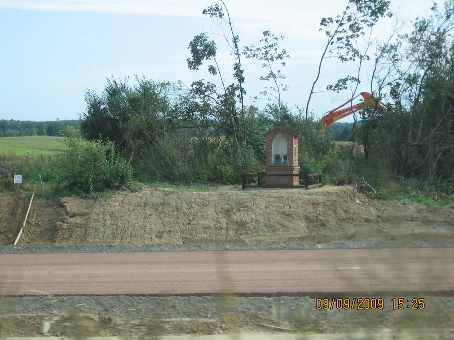
The wayside shrine on National Road 16 west of Kromerowo stands on a stone base and is built of brick. It has a rectangular floor plan. The front features a large pointed-arch niche; the side niches are narrow and tall. The contrast between the broad niche at the front and the slender forms at the sides defines its described design.
The gabled roof is covered with ceramic tiles. An iron cross and a weather vane bearing the construction date stand on the roof. The shrine is listed as an immovable monument under entry A-4526, dated 3 June 2009. Anyone interested in architectural heritage can consider both the building’s individual architectural details and its listed status.
How do the bus routes run through Kromerowo?
Municipal bus route B1 runs from Wipsowo via Ramsówko, Ramsowo, Niedźwiedź, Kromerowo and Barczewo to Klebark Mały. Kromerowo lies between Niedźwiedź and Barczewo on this route. Municipal route B2 serves Kromerowo/Wies and runs from Leszno via Barczewo, Tumiany and Klimkowo.
You can distinguish the two routes by the places named: Wipsowo and Klebark Mały are the endpoints of the route described for B1; for B2, Leszno is named as the starting point and Kromerowo/Wies as a place served. When planning your journey, compare your starting point or destination with the route itself, not just the route number.
How do the cycling route and location help with orientation?
A 60 km red cycling route passes through Kromerowo. Its length and colour marking give you two specific characteristics for identifying the route, without implying a particular journey time. This makes Kromerowo a relevant stop on a cycling trip; the stated total length describes the route, not an individual section.
The town’s location is also clearly described: Kromerowo lies south of the southern tip of Lake Dadaj. A so-called green wildlife bridge was built over National Road 16 near Kromerowo in 2010. Alongside the cycling route, both the geographical reference to the lake and a dated structure by the road can help you identify the town.
To compare it with another destination, you can also see Kaplityny.
FAQ
How long is the red cycling route through Kromerowo?
The red cycling route is 60 km long and passes through Kromerowo.
Which municipal bus routes serve Kromerowo?
Route B1 runs from Wipsowo via several towns to Klebark Mały. Route B2 serves Kromerowo/Wies and runs from Leszno via Barczewo, Tumiany and Klimkowo.
When did Kromerowo receive its charter of foundation?
Kromerowo received its charter of foundation from Bishop Marcin Kromer in the second half of the 16th century.
To the overview of destinations in the wider area: Biedowo.

