
Discover Võru: Nature, Hiking Trails and Regional Culture
Accommodation in Võru
Võru combines distinctive landscapes, varied hiking trails and a unique regional culture. Your options range from short routes with stairs and footbridges to longer trails through valleys and uplands. There are also observation towers, historic castle ruins, smoke saunas, lakes and local specialities.
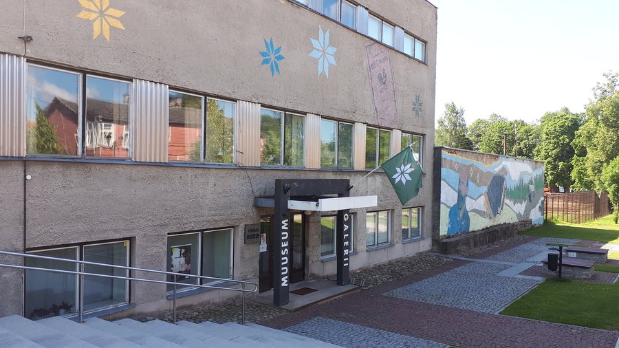 File:Museum in Võru, Estonia VANA-VÕROMAA MUSEUM 02.jpg
Photo: Klarqa via Wikimedia Commons, CC BY-SA 4.0
File:Museum in Võru, Estonia VANA-VÕROMAA MUSEUM 02.jpg
Photo: Klarqa via Wikimedia Commons, CC BY-SA 4.0
The Haanja Uplands are among the more mountainous regions of Estonia and are located in Võrumaa. At 318 m above sea level, Suur Munamägi rises as the highest peak in the Baltic States. The observation tower at the summit is 29.1 m high; in clear weather, the views extend up to 50 km.
Water and rock also shape the landscape. Rõuge Suurjärv is 38 m deep, making it the deepest lake in Estonia. The Piusa is considered the river in Estonia with the greatest difference in elevation. Härma Mäemine Wall is also known as Keldre Wall; it is 43 m high and 150 m long and is considered Estonia's highest sandstone outcrop.
Which landscapes and natural sites characterize the region?
The Piusa Valley can be experienced on the Piusa River valley hiking trail. The hiking trail runs within the Piusa River valley landscape protection area. Rebasmäe Spring is also known as Ilumetsa Spring and is considered the largest flood spring in Võru County. Access to it is via a boardwalk. First, you descend a long staircase into a shallow valley and cross a bridge over the Rebasmäe stream.
Which hiking trails suit different day plans?
The 103 km-long RMK Piusa–Pähni hiking trail includes a section considered the most difficult part of the route. Its undulating course leads through the mountains and valleys of the Haanja Uplands; this section is recommended to be covered on foot. The trail is marked with white-green-white paint markings, hiking trail signs and information boards about the route.
The Piusa matkarada begins about 50 m from Piusa railway station. The 10 km-long Rõuge Primeval Valley hiking trail follows the lakes and the relief of the valley towards Hinni Canyon. The short Ööbikuorg short hiking trail is 450 m long and includes stairs and footbridges.
Which viewpoints and high points are there?
At Suur Munamägi, the 29.1 m-high observation tower combines the elevation of the summit with a wide panorama. In clear weather, the view can extend up to 50 km. The site also has a long history of towers: the first observation tower on Suur Munamägi was built in 1812, while today's tower is the sixth in its history.
What makes the culture and regional traditions special?
Vastseliina Episcopal Castle features castle ruins dating from the 14th century and was a sacred pilgrimage site. Another cultural facet is Uma Pido, an annual summer song and folk festival held in the Võro language that brings together locals and visitors.
A tour of the Mooska Smoke Sauna Farm lasts about one and a half hours by prior arrangement, includes three distinctive smoke saunas and features a tasting of meat smoked in the smoke sauna.
Sõir is also part of the regional cuisine. The cheese is still produced by the Võrokes and Setos in households, small dairy-processing businesses, tourism farms and cafés.
How can you coordinate accommodation and travel planning?
When choosing a hotel or other accommodation in Võru, it is helpful to first consider which themes define your trip. Nature enthusiasts can focus on the trails in the Piusa and Rõuge areas, the Haanja Uplands and the viewpoints. Those more interested in history and regional identity will find different focal points in Vastseliina, Uma Pido and the smoke sauna tradition.
For further regional orientation, you can also explore Võru, Antsla, Mae–suhka, Haanja, Haanja, Vastseliina, Rõuge, Urvaste, Rõuge, Juba, Võru, Misso, Antsla, Lasva, Sõmerpalu, Varstu and Meremäe Parishrural municipality.
FAQ
How high is the Pesapuu observation tower?
The Pesapuu observation tower is 30 m high. Its upper observation platform is 27 m above the ground.
What is there to see at the RMK Pähni Nature Centre?
Three enormous wooden forest megaphones stand in a fir forest near the RMK Pähni Nature Centre. Each of these megaphones is named Ruup and has a diameter of 3 m.
What can you experience in Ööbikuorg?
Ööbikuorg has functioning hydraulic ram pumps that lift water without electricity. The Ööbikuorg Hydro-workshop Museum can also be visited by prior registration at +372 522 3206.
What activities does Tamula Beach offer?
At Tamula Beach, you can play football and volleyball, climb on the climbing net, build sandcastles and sunbathe on the lawn or sandy beach.
To the main travel overview: Estonia.

