
Wierzbanowa
Accommodation in Wierzbanowa
Wierzbanowa lies in the Krzyworzeka valley and on the slopes of Ciecień and Wierzbanowska Góra. Alongside this landscape setting, religious roadside figures, a chapel, and historic buildings shape the character of the place. Here you can consider its geographical setting and cultural features separately.
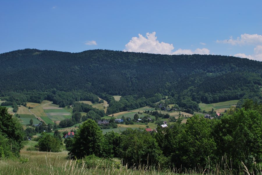 Wierzbanowa village (view from W), Myślenice county, Lesser Poland Voivodeship, Poland
Photo: Zygmunt Put Zetpe0202 via Source, CC BY-SA 4.0
Wierzbanowa at a glance
- The village lies at the transition between Beskid Średni and Beskid Wyspowy.
- On the road to Wiśniowa are a figure of Saint John of Nepomuk dating from 1847 and a figure of Christ dating from 1864.
- Wierzbanowa has a small brick chapel of the Crucifixion of the Lord from the 19th century.
- A rather simple figure of the Virgin Mary dating from 1885 stands on Przełęcz Wierzbanowska.
- Some wooden houses from the early 20th century have decorated gables.
- The village also has a school building from the early 20th century.
How can Wierzbanowa’s location be described?
Three details are important to the landscape: the Krzyworzeka valley, the slopes of Ciecień and Wierzbanowska Góra, and the transition between two Beskid regions. A valley is lower-lying terrain; a slope is the inclined side of a rise. Together, these terms describe both the nearby terrain and the broader regional setting.
The location is therefore defined not only by the names of the two Beskid regions. The valley and the two named slopes are also part of its geographical setting. If you compare destinations by landscape, Wierzbanowa thus offers several specific reference points rather than just a general association with the mountains.
What are Wierzbanowa’s historic features?
The two figures on the road to Wiśniowa share a location but differ in subject and date. The figure of Saint John of Nepomuk dates from 1847; the figure of the crucified Christ is dated 1864. Another roadside figure stands on Przełęcz Wierzbanowska: the Immaculate Conception of Mary, dating from 1885. It is described as rather simple.
The Chapel of the Crucifixion of the Lord adds a different type of building to these figures. It is small, built of brick, and dates from the 19th century. A different architectural detail stands out in the wooden houses from the early 20th century: their decorated gables. A gable is the upper end of a house wall beneath the roof. This helps make sense of the information about the houses not only in terms of their construction and period, but also by reference to a specific architectural feature.
Another building from the early 20th century is the school. Chronologically, it belongs with the wooden houses, rather than with the chapel and the figures dated to the 19th century. The places and buildings mentioned therefore offer different ways to explore Wierzbanowa’s cultural heritage: religious figures, a chapel, and buildings with different architectural features.
How do the historic dates differ?
The three roadside figures form a clear sequence: 1847, 1864, and 1885. The dates span several decades, making the differences between the figures apparent in chronological terms as well. The chapel is dated to the 19th century; the wooden houses and the school building date from the early 20th century. The features mentioned thus span the 19th to the early 20th century, with specific years given for the figures and only a broader period specified for the buildings.
Discover more destinations: Glichów, Lubień, Dobczyce, Osieczany, Myslenice, Sułkowice, Krzczonów and Borzęta.
FAQ
Between which Beskid regions is Wierzbanowa located?
Wierzbanowa lies at the transition between Beskid Średni and Beskid Wyspowy, in the Krzyworzeka valley and on the slopes of Ciecień and Wierzbanowska Góra.
Which roadside figures are dated?
The figure of Saint John of Nepomuk dates from 1847, the figure of Christ on the road to Wiśniowa from 1864, and the figure of the Virgin Mary on Przełęcz Wierzbanowska from 1885.
Which historic buildings are mentioned?
These include a small brick chapel from the 19th century, some wooden houses with decorated gables, and a school building from the early 20th century.
For the broader travel overview: Myślenice.

