
Szczytna – Culture and Hiking Trails on Szczytnik
Accommodation in Szczytna
Szczytna lies between the Stołowe Mountains and the Bystrzyckie Mountains, on the Bystrzyca Dusznicka River. If you are looking for a destination with historic buildings and hiking and cycling routes of varying lengths, you will find several concrete points of reference here to help plan your trip.
Szczytna at a glance
National Road DK8 between Wrocław and Kudowa-Zdrój runs through the town, as does the railway line from Kłodzko to Kudowa-Zdrój. Notable buildings include the Baroque Church of St. John the Baptist, whose construction was completed in 1726. A yellow hiking trail leads uphill from Szczytna to Szczytnik: the ascent is 1.3 km long and takes about 40 minutes.
The Baroque Church of St. John the Baptist is one of Szczytna’s distinctive buildings. Its construction was completed in 1726. On Sienkiewicza Street, above Kamienny Potok, there is also a listed statue of St. John of Nepomuk dating from 1711. It is another historic landmark in the townscape.
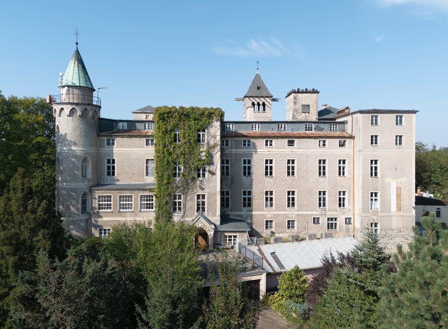
On rocky Szczytnik, above Szczytna, stands Leśna Skała, a Neo-Gothic palace built as a hunting residence between 1831 and 1838. Its terrace offers far-reaching views over the surrounding landscape. Also on Szczytnik, a fort was built between 1790 and 1795 as part of a line of fortifications intended to warn the Kłodzko Fortress of approaching enemy armies. The different dates and functions of these structures also make Szczytnik interesting for travelers who want to explore historic architecture and regional history alongside the landscape.
What hiking routes are available?
The yellow trail from Szczytna to Szczytnik is described as 1.3 km long, with an ascent taking about 40 minutes. For a longer hike, consider “Ze Szczytnej na Wolarz”: this 11.1 km circular route leads to the 852 m-high Wolarz in the Bystrzyckie Mountains and starts at a historic railway station dating from 1890. Its stated length and circular format make it quite different from the short ascent to Szczytnik.
Another option is the 14.1 km hike “Na Muflon.” It begins at the intersection of International Road 8 and Sienkiewicza Street, by the statue of St. John of Nepomuk. The destination, Schronisko pod Muflonem, is outside the municipality; most of the route runs within the municipality of Szczytna. These location details help clarify the route without conflating its starting point and destination.
What cycling routes and activities are available?
For a longer bike ride, there is an approximately 50 km linear route from Szczytna to Bystrzyca Kłodzka. You can take trains for the return journey or to complete the route. A 127 km blue cycling loop around the Stołowe Mountains also runs north of Szczytna. It follows paved roads along the Polish-Czech border for its entire length.
Szczytna’s sports, active recreation, and movement therapy center has three artificial-turf pitches and a high ropes course with a climbing wall. A recurring event is the Skatepiknik Integracyjny, held annually since 2010 and featuring an Olympics for preschool children. The tours, sports facilities, and event each offer a different focus, so you can choose according to your travel group’s interests.
If you would like to compare more destination pages, you can also find Kąty Bystrzyckie, Leśna, Kłodzko, Duszniki-Zdrój, Trzebieszowice, Wójtowice, Sienna and Młynowiec here.
FAQ
How long is the yellow hiking trail to Szczytnik?
The ascent from Szczytna is 1.3 km long and takes about 40 minutes.
Which longer hike leads to Wolarz?
“Ze Szczytnej na Wolarz” is an 11.1 km circular route to the 852 m-high Wolarz in the Bystrzyckie Mountains.
Which historic attraction is located on Szczytnik?
On rocky Szczytnik, above Szczytna, stands the Neo-Gothic palace Leśna Skała, built as a hunting residence between 1831 and 1838. Its terrace offers wide-ranging views of the surrounding landscape.
For the broader travel overview: Kłodzki.

.jpg)