
Santoczno – Waterscapes and Ironworks History
Accommodation in Santoczno
Santoczno lies on a lake and a river; its buildings and ruins also tell the story of the former ironworks. When planning your trip, the village brings together waterscapes, local history, and marked routes for you to explore according to your interests.
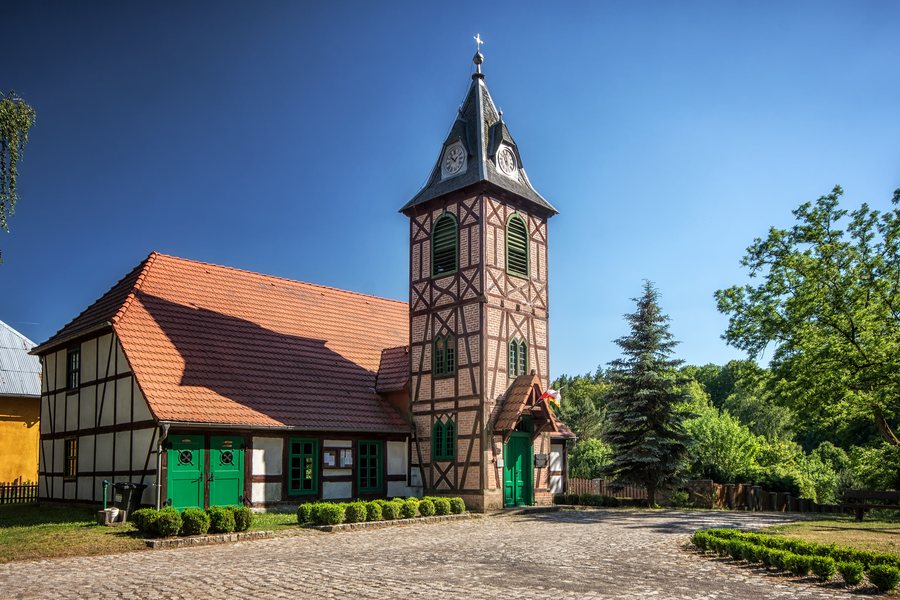 File:SM Santoczno Kościół Przemienienia Pańskiego 2020 (5).jpg
Photo: Sławomir Milejski via Wikimedia Commons, CC BY 3.0
File:SM Santoczno Kościół Przemienienia Pańskiego 2020 (5).jpg
Photo: Sławomir Milejski via Wikimedia Commons, CC BY 3.0
Santoczno at a glance
Santoczno lies along the glacial trough of Lake Mrowinko, which covers 22.5 ha, and the Santoczna River, which flows out of the lake. The village has a half-timbered church and a Neoclassical former vicarage. Other historical traces include the ruins of a watermill and an ironworks. A blue-marked cycle route passes through several places on its way to Santoczno; a green hiking trail is also listed, with a stated length of 7.9 km (12.3 km).
What shapes the landscape around Santoczno?
The lake and river offer two distinct points of reference: Mrowinko lies in a glacial trough, while the Santoczna flows out of the lake. A waterfall on the Santoczna is also one of the village’s notable features. Near the bridge and waterfall is a small lapidarium with tombstones from a former German cemetery. If you would like to combine nature and local history, the river provides a shared point of reference.
A beech tree in Santoczno is protected as a natural monument. Its trunk circumference is more than four metres, and its age is estimated at about 200 years. The age is an estimate. This tree monument adds a distinct natural feature to the waterscape.
What historical traces can you find in the village?
The single-nave half-timbered church, with galleries, was created by converting a former ironworks warehouse dating from 1767. A tower was added in 1819; it houses two bells from a Berlin bell foundry. Since 2005, a glacial erratic in the square in front of the church has commemorated the former ironworks. It is accompanied by a cast of a plaque depicting a model of the first German steam engine.
The former ironworks produced wire, nails, and bar iron. Its ruins can be found in Santoczno, as can those of a former watermill. The Neoclassical former vicarage dates from the 19th century, was extended with a wing in the 20th century, and has a half-hipped roof. Together, these sites show different aspects of local architectural and industrial history, without needing to be treated as a single historical complex.
Which routes and distances can you plan for?
The blue-marked cycle route runs 32 km from Gorzów Wlkp. to Santoczno via Czechów, Santok, Brzezinka, and Górki Noteckie. The Santoczno–Santok section passes through the picturesque valley of the Santoczna. The stated total distance provides a specific value for planning a cycling trip; the valley section offers its own landscape to explore.
The stated length of the green Górki Noteckie–Zdroisko–Santoczno hiking trail is 7.9 km (12.3 km). The two routes differ in both their markings and their stated lengths.
You can compare other places separately: Deszczno, Rybakowo, Landsberg An Der Warthe, Küstrin, Witnica, Kłodawa, Wojcieszyce and Zdroisko.
FAQ
How large is Lake Mrowinko?
Lake Mrowinko covers 22.5 ha. The Santoczna flows out of it.
How long is the cycle route to Santoczno?
The blue-marked cycle route from Gorzów Wlkp. to Santoczno via Czechów, Santok, Brzezinka, and Górki Noteckie is 32 km long.
How long is the green hiking trail?
The stated length of the green Górki Noteckie–Zdroisko–Santoczno hiking trail is 7.9 km (12.3 km).
What commemorates the ironworks in Santoczno?
The historical traces include the ruins of the former ironworks, the church in the ironworks’ former warehouse, and a glacial erratic placed in the square in front of the church in 2005.
For the broader travel overview: Landsberg an der Warthe.

.jpg)