
Ochotz
Accommodation in Ochotz
If you would like to consider culture, cycling and landscape conservation when choosing a destination, Ochotz (Ochodze) offers specific points of interest: a relocated wooden church with distinctive features, documented cycling routes and a protected landscape area in the southern part of the village.
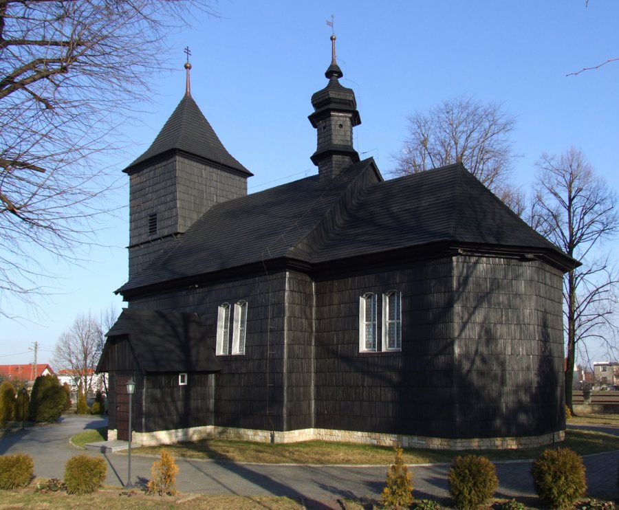 File:Schrotholzkirche in Ochotz.jpg
Photo: Pudelek (Marcin Szala) via Wikimedia Commons, CC BY-SA 3.0
File:Schrotholzkirche in Ochotz.jpg
Photo: Pudelek (Marcin Szala) via Wikimedia Commons, CC BY-SA 3.0
Key facts about Ochotz
- The southern part of Ochodze lies within the “Bory Niemodlińskie” Protected Landscape Area, which was established on 26 May 1988.
- The wooden Church of St Martin and Our Lady, Queen of the World, was built in Komprachcice in 1702 and relocated to Ochodze in 1942.
- The official cycling guide for the Opole Voivodeship lists the alternative route “Ochodze–Opole-Chmielowice”.
- A stretch of the A4, approximately 1,690 metres long, runs through the area of Ochodze.
What makes the landscape around Ochotz distinctive?
The “Bory Niemodlińskie” Protected Landscape Area covers the southern part of Ochodze. It was established by Resolution No. XXIV/193/88 of the Voivodeship Council in Opole on 26 May 1988. The geographical detail is important for orientation: it refers to the southern part of the village, not to all of Ochodze.
This makes it possible to define Ochotz’s connection with the landscape more precisely, without extending it to the entire village. If landscape and nature are a particular priority when planning your trip, you can consider this southern part as a distinct aspect of the village. The name of the protected area and its date of establishment provide a specific historical and geographical reference.
What are the distinctive features of the wooden church?
The Church of St Martin and Our Lady, Queen of the World, has a history that can be traced through two dates: it was built in Komprachcice in 1702 and relocated to Ochodze in 1942. Its original location and later site are therefore different. The years refer to these two events; they should not be understood as construction dates for two different churches.
Individual details also make the church noteworthy for travellers interested in culture. A Karawaka cross with two crossbars, the lower one longer than the upper, sits atop the tower. The interior and furnishings also include a baptismal font in the Baroque folk style. The shape of the cross and the baptismal font offer two different points of interest if you are interested in the design of historic religious buildings.
What other historic buildings are there?
In addition to the wooden church, a chapel and a building at Myśliwska 1 are associated with specific construction years. A brick chapel built in 1878 stands on Średnia Street. The building at Myśliwska 1 dates from 1882 and is now used as a residence and restaurant. The two examples can be distinguished by their construction, address and function: the brick chapel on Średnia Street on the one hand, and a building now used as a residence and restaurant on the other.
For a cultural walk, this information first provides an overview of the buildings described and their features. The church is characterised by its relocation history and furnishings, while the chapel and the house at Myśliwska 1 are identified by their location and year of construction. This can help you decide which aspects of the village’s history are of particular interest for your trip.
Which cycling routes and transport routes are described?
The official cycling guide for the Opole Voivodeship lists an alternative cycling route named “Ochodze–Opole-Chmielowice”. Another route description concerns Route 2.B: after crossing the A4, it leads from the forest to Ochodze via an overpass. The information therefore identifies both a named alternative route and a specific point along Route 2.B. If you compare routes, be sure to distinguish between these names and descriptions.
The motorway can also be located precisely. A stretch of the A4, a class A motorway, approximately 1,690 metres long, runs through the area of Ochodze. The A4 runs along the Jędrzychowice–Wrocław–Katowice–Kraków–Korczowa route. The stated length describes the section within the village area; it is not the length of the cycling route or a distance between attractions.
Which other places can you compare?
For other place pages in the travel guide, you can also visit Proskau, Grabin, Bierdzan, Polnisch Neudorf, Niemodlin, Przysiecz, Zedlitz and Dembiohammer.
FAQ
Which part of Ochodze lies within the Protected Landscape Area?
The southern part of Ochodze lies within the “Bory Niemodlińskie” Protected Landscape Area. It was established on 26 May 1988.
When was the wooden church relocated to Ochodze?
The church was built in Komprachcice in 1702 and relocated to Ochodze in 1942.
Which cycling route is called Ochodze–Opole-Chmielowice?
The official cycling guide for the Opole Voivodeship lists it as an alternative cycling route. Route 2.B is also described as running via an overpass from the forest to Ochodze after crossing the A4.
For the broader travel overview: Opolski.

