
Bielowy: Historic Village Center and Cultural Landscape
Accommodation in Bielowy
In Bielowy, local history can be read in both the settlement layout and individual architectural landmarks. If you choose a stay based on cultural themes, you can consider the spatial structure and historical building periods as distinct points of reference.
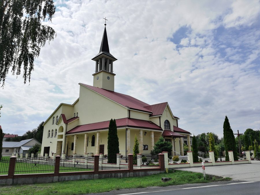 File:JKRUK 20180816 BIELOWY kaplica Bożego Miłosierdzia IMG 135941.jpg
Photo: Jarosław Roland Kruk via Wikimedia Commons, CC BY-SA 4.0
Bielowy at a glance
- The historic village center remains legible in its spatial structure along the main road; the road follows a section of the former route from Pilzno to Jasło.
- The Przymiarki stream forms the axis of the strip-field village layout. Long rows of farmsteads line the roads on both banks; field strips run perpendicular to them.
- The Chapel of Pana Jezusa Miłosiernego was built from 1986 to 1994. A wooden wayside shrine from the 19th century hangs on a tree.
- The Jasielsko–Dębicko–Ropczycki section of the Szlak Architektury Drewnianej runs through Bielowy. For 2012–2015, the smithy was described as abandoned and increasingly dilapidated; roof repairs were required.
What does the village layout reveal about Bielowy?
Here, the term strip-field layout describes a spatial pattern made up of several directions. The Przymiarki stream forms the axis of the village layout. Along the roads on both banks, rows of farmsteads extend in long lines; field strips adjoin them at right angles. The settlement form can thus be understood as an interplay of the stream axis, roadside buildings, and the arrangement of fields.
This arrangement provides more guidance than looking at individual buildings alone: the farmsteads follow the length of the roads, while the fields change direction. It is precisely this shift between longitudinal and transverse alignments that makes the village’s structure legible. The field strips are therefore not merely an addition to the buildings, but part of the described village layout.
A second spatial relationship can be seen along the main road. It follows a section of the former route from Pilzno to Jasło. Thus, alongside the settlement pattern by the stream, this historic road route is also relevant to understanding the village center. The stream axis and the route connection represent different aspects: the settlement’s form and its location on a former connecting road.
Which cultural landmarks are identified in Bielowy?
The Chapel of Pana Jezusa Miłosiernego was built between 1986 and 1994. The wooden wayside shrine hanging on a tree, by contrast, dates back to the 19th century. Its folk-style depiction shows Christ in distress. Their different construction periods provide two distinct points of reference for the religious landmarks in Bielowy.
The smithy is also among the identified traces of local history. In the Municipality of Pilzno’s heritage conservation program for 2012–2015, it was described as abandoned and increasingly dilapidated; roof repairs were required. This information relates to that period. It therefore differs from the chapel’s construction dates, which indicate when it was built.
The Jasielsko–Dębicko–Ropczycki section of the Szlak Architektury Drewnianej, the Wooden Architecture Trail, runs through Bielowy. This route connection places the village within a named cultural theme; the chapel, the wayside shrine, and the smithy are local architectural and cultural landmarks. When considering Bielowy’s cultural context, you can distinguish between the route of the themed trail and the history of individual buildings.
Discover more destinations: Strzegocice, Dębica, Brzeźnica, Grabiny, Żdżary, Żyraków, Łęki Dolne and Parkosz.
FAQ
How is Bielowy’s village layout structured?
The Przymiarki stream forms the axis. Rows of farmsteads follow the roads on both banks; field strips run perpendicular to them.
Which former route does the main road follow?
It follows a section of the former route from Pilzno to Jasło.
Which religious landmarks are identified?
The Chapel of Pana Jezusa Miłosiernego was built from 1986 to 1994. A wooden wayside shrine from the 19th century depicts Christ in distress.
Which wooden architecture trail runs through Bielowy?
It is the Jasielsko–Dębicko–Ropczycki section of the Szlak Architektury Drewnianej.
For the broader travel overview: Dębica.

