
Okartowo: Church, Cemetery and Cycle Route
Accommodation in Okartowo
Okartowo lies on an isthmus between two lakes. Church art, an Evangelical cemetery and an 85 km cycle route offer different points of reference for getting to know the place as you plan your trip.
Key facts about Okartowo
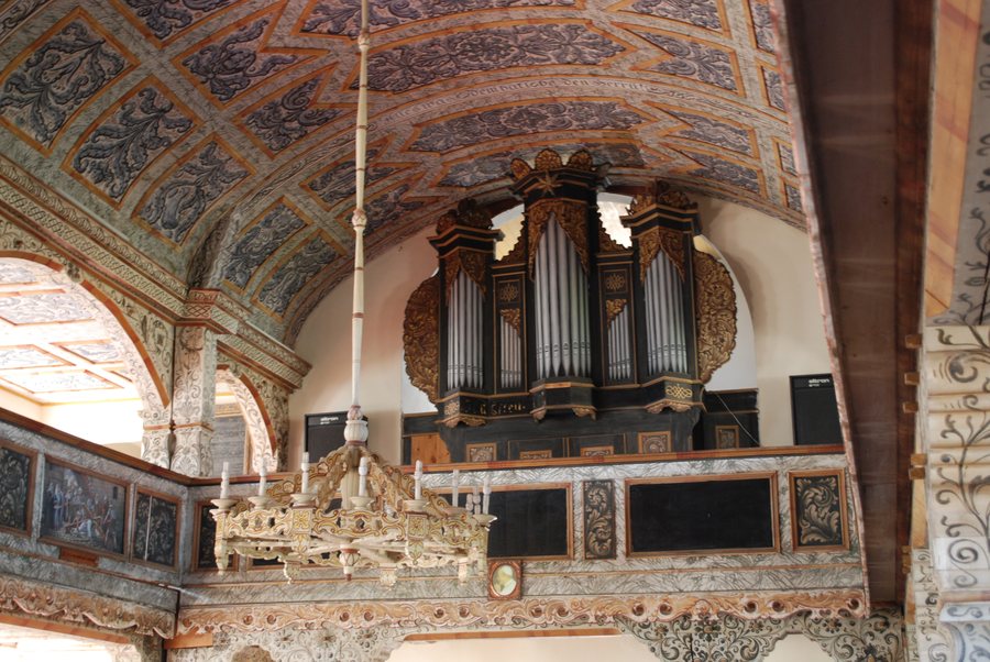
Okartowo lies on the isthmus connecting Lakes Śniardwy and Tyrkło. The church has a Baroque high altar and a pulpit. The Evangelical cemetery dates from around the turn of the 20th century. An 85 km cycle route runs from Mikołajki via Wierzba, Wejsuny, Niedźwiedzi Róg, Karwik, Jeglin, Zdory, Kwik, Nowe Guty, Okartowo, Suchy Róg and Dziubiele to Łuknajno, then back to Mikołajki.
What is Okartowo’s geographical setting?
The isthmus gives Okartowo a clearly defined geographical setting: the village lies on the connection between Śniardwy and Tyrkło. This puts two specific lakes at the heart of your orientation. If you consult a map while planning your trip, you can locate Okartowo through this relationship and associate the village name with both bodies of water. This is a different point of reference from a church’s features or the course of a cycle route.
What cultural traces can you explore?
The church in Okartowo has a Baroque high altar and a pulpit. These are two distinct elements of a church interior: the high altar is part of the altar design, while the pulpit is used for preaching. The Baroque style designation applies to the high altar; the pulpit is mentioned as another furnishing. This allows you to consider two different aspects of the church without conflating them.
Another point of historical reference is the Evangelical cemetery. It dates from around the turn of the 20th century, or approximately 1900. Together, these offer two distinct ways to explore the area’s cultural heritage: the church furnishings and the cemetery’s history. When comparing historic sites, you can consider both their design and their historical period.
What is the route of the cycle path through Okartowo?
The route described runs from Mikołajki via Wierzba, Wejsuny, Niedźwiedzi Róg, Karwik, Jeglin, Zdory, Kwik, Nowe Guty, Okartowo, Suchy Róg and Dziubiele to Łuknajno, and then back to Mikołajki. Okartowo is therefore on a route that passes through several named places. The total length is 85 km; this distance is important to consider if you plan to include the cycle route in your trip.
For your own ride, you can first decide which part of the route you want to cover. The sequence of places makes clear that Okartowo is one stop on a longer route. Before setting out, check the current route and signage. This will help you assess the route according to your own plans, rather than automatically treating the total distance as the length of your personal stage.
What information can help you decide whether to visit?
Three interests come together when choosing Okartowo as a destination: its location on the isthmus between the lakes, its church furnishings and historic cemetery, and the cycle route. If you are looking for a hotel, you can first compare these features with your travel plans. This will help you decide whether the location, culture or cycling is the main draw for you.
Discover more destinations: Nowe Guty, Bełcząc, Gałkowo, Iznota, Biala Piska, Pogobie Średnie, Pilchy, Szczechy Wielkie.
FAQ
Which lakes does the isthmus near Okartowo connect?
The isthmus on which Okartowo lies connects Lakes Śniardwy and Tyrkło.
What cultural details are mentioned for Okartowo?
The church has a Baroque high altar and a pulpit. The Evangelical cemetery dates from around the turn of the 20th century.
How long is the cycle route through Okartowo?
The cycle route is 85 km long. It passes through Okartowo on its way from Mikołajki to Łuknajno and back to Mikołajki.
Go to the main travel overview: Piski.

