
Gollnow
Accommodation in Gollnow
Gollnow combines the Ina River with medieval buildings, protected woodland, and marked trails. This means you can choose between local history, nature, and a range of ways to explore on foot or by bike during your trip.
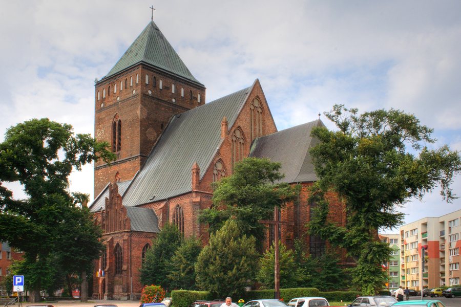 Kościół św. Katarzyny w Goleniowie
Photo: Remigiusz Józefowicz via Wikimedia Commons, CC BY-SA 2.5 pl
Kościół św. Katarzyny w Goleniowie
Photo: Remigiusz Józefowicz via Wikimedia Commons, CC BY-SA 2.5 pl
Gollnow at a glance
- The Ina River flows through the municipality of Goleniów and the town of Goleniów.
- Brama Wolińska, also known as Brama Chrobrego, is a Gothic defensive gate from the 14th century, standing 26 metres tall and spanning six storeys.
- The routes described include a 17.1-kilometre hiking trail and cycling routes measuring 45 and 13 kilometres.
- The Wilcze Uroczysko and Uroczysko Święta nature reserves preserve different woodland and wetland habitats.
What local history can you discover?
Brama Wolińska is a prominent part of the town's history. Built in the Gothic style in the 14th century, this defensive gate is also known as Brama Chrobrego. At 26 metres tall and with six storeys, it gives a sense of the scale of the structure. The Centrum Informacji Turystycznej is located in the passageway.
Significant sections of the medieval town walls have survived. The most interesting and best-preserved section lies southwest of the Old Town, beside the Ina River. Also by the river stands the Spichlerz, a distinctive, detached three-storey building with a converted attic. It was built in 1749 and stands parallel to the river, about twelve metres from the bank.
The townscape also includes more recent uses of historic buildings. Twierdza Design is a historic industrial site developed from a railway water tower. The tower was renovated in 2019–2020; Twierdza Design is used by social organisations. The Goleniowska Aleja Legend also runs along the Ina River: a riverside promenade renovated in 2013, with granite sculptures depicting local legends.
Which natural areas shape the surrounding landscape?
Wilcze Uroczysko covers just under 63 hectares and extends across the municipalities of Goleniów and Stepnica. The nature reserve protects a marsh and valuable riparian woodland; it also provides a refuge for white-tailed eagles.
Uroczysko Święta has a different conservation purpose. Established in 1973, this 9.5-hectare nature reserve is located in the Goleniów Forest District. As a floristic reserve, it protects part of a deciduous woodland. Those interested in nature and landscapes can explore two distinct environments: wetlands and riparian woodland at Wilcze Uroczysko, and protected deciduous woodland at Uroczysko Święta.
In Lubczyna, Przystań Jachtowa offers water-based tourism. It has three harbour basins with space for around 35 inland yachts and 15 sea-going yachts.
What routes are available for walks and cycling trips?
The Miejski Szlak Turystyczny takes you to architectural landmarks and places of interest in Goleniów. It is marked with what are known as blue footprints. The green PTTK hiking trail Szlak Borów Goleniowskich is another option for a walk or cycle ride through the places mentioned. It is 17.1 kilometres long, well marked, and particularly recommended for hikers and cyclists. The route runs between Krzewno, Łęsko, Pucko, and Kliniska Wielkie.
Two other routes are described for cycling. The green cycling route is 45 kilometres long and passes through Goleniów, Żdzary, Łaniego, Krępsko, Miękowo, Żółwią Błoć, Niewiadowo, Glewice, Stacja PKP Mosty, Burowo, and Mosty. The 13-kilometre sentimental cycling route runs through Borzysławiec, Lubczyna, Czarna Łąka, Pucice, and Rurzyca. Comparing the different lengths and sequences of places can help you match the described routes to your own cycling plans.
Where can you get tourist information?
The Centrum Informacji Turystycznej is located in the passageway of Brama Wolińska. It provides information about tourist infrastructure, agritourism and tourism, as well as places of interest in the town and region. The centre also provides information on cycling routes and cultural and sporting events.
Other locations in this overview: Łęgno, Załom, Lubczyna, Maciejewo, Przybiernów, Kliniska Małe, Długołęka, Miodowice, Stepniczka, Budzieszowce, Goleniów, Nowogard, Babigoszcz, Wyszomierz, Maszewo, Żarnówko and Dąbrowica.
FAQ
How is the Miejski Szlak Turystyczny marked?
The trail is marked with what are known as blue footprints and takes you to architectural landmarks and places of interest in Goleniów.
How long is the Szlak Borów Goleniowskich?
The green PTTK hiking trail is 17.1 kilometres long and runs between Krzewno, Łęsko, Pucko, and Kliniska Wielkie.
What distinguishes the two nature reserves?
Wilcze Uroczysko covers just under 63 hectares in the municipalities of Goleniów and Stepnica and protects, among other things, a marsh and riparian woodland. Uroczysko Święta covers 9.5 hectares in the Goleniów Forest District and, as a floristic reserve, preserves part of a deciduous woodland.
Where can you find the Centrum Informacji Turystycznej?
It is located in the passageway of Brama Wolińska and provides information on attractions, cycling routes, and cultural and sporting events, among other things.
Go to the main travel overview: West Pomerania.

