
Discover Transnistria: Culture, Nature and Waterways
Accommodation in Transnistria
Transnistria combines historic buildings, distinctive landscapes, villages, waterways and routes of varying lengths.
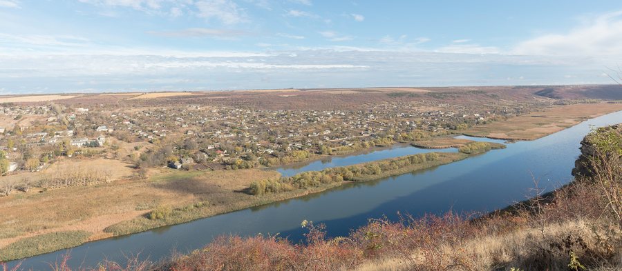 File:Popencu, Transnistria, Moldavia, 2023-11-01, DD 15.jpg
Photo: Diego Delso via Wikimedia Commons, CC BY-SA 4.0
File:Popencu, Transnistria, Moldavia, 2023-11-01, DD 15.jpg
Photo: Diego Delso via Wikimedia Commons, CC BY-SA 4.0
Longer activities include a 129-kilometre network of routes through seven villages, a 63-kilometre northern water route and a 74-kilometre hiking route from Camenca to Rybnitsa. The Tiraspol–Chobruchi water route is designed as a three-day, 44-kilometre journey. Cultural sites include the former synagogue in Rashkov, Noul Neamt Monastery and the Church of Saint Kaetan.
The landscape also provides clear points of reference. D.K. Rodin Park in Chobruchi was designed in 1958 by sculptor Dmitry Rodin as a landscape composition of stone, water, vegetation and sky. Near Rashkov, Chervona Rock reaches a length of approximately 500 metres and a height of 50 metres. The Dubăsari Dam is a hydroelectric dam on the Dniester near Dubăsari in Transnistria, Moldova.
Which landscapes define the region?
Rodin Park represents a deliberately designed connection between nature and art. Its landscape composition brings together stone, water, vegetation and sky and is based on the work of sculptor Dmitry Rodin. The park was created in 1958.
The Chervona Rock near Rashkov shows a different dimension. The rock formation is approximately 500 metres long and reaches a height of 50 metres.
Which hiking routes can be compared with one another?
The Ecological Trails of the North form a 129-kilometre network of routes. It connects the seven villages of Valya-Adynka, Konstantinovka, Rashkov, Sadki, Katerinovka, Belochi and Stroentsy in the Kamensky and Rybnitsa districts. The network comprises 31 stations in total. These include natural cliffs, old cemeteries, rural markets, museums and historic churches.
The 31 stations range from natural cliffs and old cemeteries to rural markets, museums and historic churches.
The six-day hiking route from Camenca to Rybnitsa follows a different timeframe. It is 74 kilometres long and passes forests, springs, caves, Orthodox monasteries and Soviet military monuments. This does not imply anything about the individual difficulty or actual accessibility of the individual sections.
What do the waterways offer?
The northern water route is a 63-kilometre journey by kayak or boat. It connects Rashkov with the aristocratic cultural heritage of Stroentsy.
The water route Tiraspol–Chobruchi follows a significantly longer timeframe than a short excursion: it is designed as a three-day, 44-kilometre journey. Kayaks, tourist rafts, catamarans or Jalu boats are used. The route begins at Tiraspol city beach; the organisers provide the necessary tourist equipment.
Which historic sites give the journey its substance?
Rashkov is home to a former Baroque-style synagogue built in 1749. It survives only as a ruin; its exterior walls and part of the Aron ha-Kodesh remain intact. Its state of preservation is inseparable from its historical classification here. The building should therefore not be equated with a fully preserved synagogue.
Noul Neamt Monastery is another cultural focal point. In addition to its churches, the complex includes a library and a museum. The existing workshops cover the production of icons, sculpture and carpentry; these facilities are accessible to guests.
The Church of Saint Kaetan also has a clear chronology: it was completed in 1786 and consecrated in honour of Saint Kaetan five years later.
What can you experience in Tiraspol and with the regional cuisine?
Tiraspol is home to one of Europe’s largest sturgeon farms. Visitors can watch the processing of black caviar there. A dining establishment also offers traditional Moldovan dishes and teaches visitors how they are prepared.
As part of its educational work, the Iagorlîc Reserve offers free excursions for school pupils and students.
How should you incorporate hotels and accommodation into your planning?
The three-day water route begins in Tiraspol, the northern water route connects Rashkov and Stroentsy, and the six-day hiking route leads from Camenca to Rybnitsa. These routes therefore include different places in the region.
The distances range from 44 to 129 kilometres. They say nothing about the location or facilities of individual hotels. For further regional orientation, you can also visit the pages on Tirnauca and Ribnita.
Which places help with regional orientation?
If you would like to broaden your regional perspective beyond Transnistria, you can also include Călărași District, Soldanesti, Sîngerei District, Drochia District and Ialoveni District in your further planning.
FAQ
Which facilities are part of Noul Neamt Monastery?
Noul Neamt Monastery has four churches, a library and a museum. There are also workshops for producing icons, sculpture and carpentry. These workshops are accessible to guests.
How large is the Dubăsari Reservoir?
The Dubăsari Reservoir is 128 kilometres long. Its water surface covers 67.5 square kilometres.
How long is the village loop through Stroentsy?
The village loop through Stroentsy is 17.5 kilometres long, includes six stations and takes just over an hour.
When was the Church of Saint Kaetan completed and consecrated?
The Church of Saint Kaetan was completed in 1786 and consecrated five years later, in 1791, in honour of Saint Kaetan.
Back to the main travel overview: Moldova.

