
Kąclowa: Mountain Landscape and Sacred Architectural Heritage
Accommodation in Kąclowa
Kąclowa lies in the Biała Valley, surrounded by named hills and mountain ranges. The landscape, St. Adalbert's Church, and a historic chapel give the village a distinctive character. A hiking trail and a cycling route pass through Kąclowa, offering different perspectives on the surrounding area.
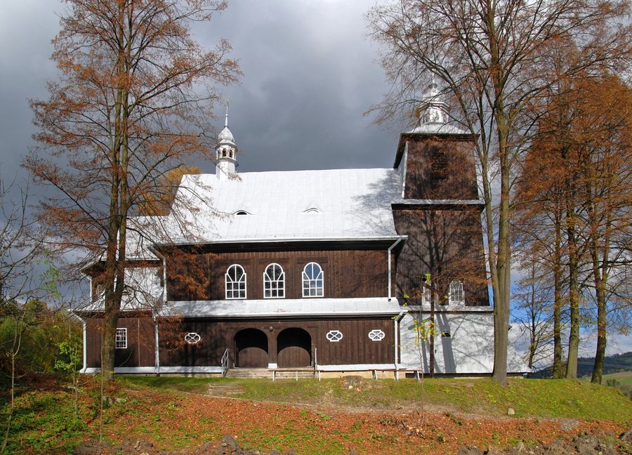 File:Kąclowa, kościół św. Wojciecha (HB1).jpg
Photo: Henryk Bielamowicz via Wikimedia Commons, CC BY-SA 4.0
Quick facts about Kąclowa
- The village lies at an elevation of about 400 m in the valley of the Biała River, at the foot of Chełm (779 m).
- To the west are Modynianka (679 m) and Jaworze (882 m), and to the north Rosochatka (753 m); to the south are Mała Kiczerka (545 m), Dział (682 m), Ubocz (620 m), and Wojenna Góra (794 m).
- St. Adalbert's Church is part of the Wooden Architecture Route in Lesser Poland. A chapel dedicated to Our Lady of Częstochowa was built in 1858.
- A green hiking trail runs from Grybów through Kąclowa toward Jaworze. A cycling route passes through Kąclowa between Ptaszkowa and Grybów.
What shapes the landscape around Kąclowa?
The Biała's valley setting is a good starting point for placing Kąclowa geographically: the village lies at an elevation of about 400 m, with Chełm, at 779 m, rising to the east. Modynianka and Jaworze lie to the west; at 882 m, Jaworze is the highest of the elevations listed here. Rosochatka lies north of Kąclowa, while several other hills are spread to the south: Mała Kiczerka, Dział, Ubocz, and Wojenna Góra.
The names and elevations paint a varied landscape rather than focusing attention on a single mountain. Kąclowa is particularly known for its beautiful views in the Chełm area. If you take the landscape and terrain into account when choosing a destination, the directional details can help you picture the village and its surroundings.
Which buildings tell the story of the village?
St. Adalbert's Church is part of the Wooden Architecture Route in Lesser Poland. It was built between 1926 and 1929 to a design by Z. Mączeński, who based it on the traditional regional building style. The church also has an organ dating from 1793. This brings together two distinct dates: the building was constructed in the 20th century, while the organ dates from the 18th century.
The Chapel of Our Lady of Częstochowa marks another point in the area's history. It was built in 1858, funded by Stanisława Skraba. Its exterior is described in specific terms: the chapel is built of stone, plastered, and covered with roof tiles. The semicircular entrance is closed by an openwork gate.
The interior is also defined by specific motifs: the chapel contains an image of Our Lady of Częstochowa and statues of the Sacred Hearts of Jesus and Mary. The two buildings can therefore be distinguished by different features: the design date, regional architectural style, and organ are central to St. Adalbert's Church, while the chapel is characterized by its construction date, materials, and religious artwork.
How do the hiking trail and cycling route pass through Kąclowa?
A green hiking trail runs from Grybów through Kąclowa toward Jaworze. Its described direction links these three specific landmarks, but does not specify a distance or walking time. For planning, the stated route is what matters most: Grybów is at the start, Kąclowa is along the way, and Jaworze lies in the indicated direction.
The cycling route follows a different described course: it runs from Ptaszkowa via Królowa, Bogusza, Binczarowa, and Kąclowa to Grybów, then back to Ptaszkowa. Both routes pass through Kąclowa, but differ in their named starting and ending points and the sequence of places listed. If you include the cycling route in your travel plans, check the latest route information before setting out.
Discover more destinations: Łącko, Gródek Nad Dunajcem, Krynica-Zdrój, Jazowsko, Rożnów, Wierchomla Wielka, Zubrzyk, Stary Sącz.
FAQ
Which hills are around Kąclowa?
Chełm (779 m) lies to the east, while Modynianka (679 m) and Jaworze (882 m) lie to the west. Rosochatka (753 m) is to the north; four other named hills lie to the south.
What is known about St. Adalbert's Church?
It is part of the Wooden Architecture Route in Lesser Poland and was built between 1926 and 1929 to a design by Z. Mączeński. Its organ dates from 1793.
What is the cycling route through Kąclowa?
It runs from Ptaszkowa through several places, including Kąclowa, to Grybów and back to Ptaszkowa. Check the latest route information before setting out.
Go to the main travel overview: Nowy Sącz.

