
Discover Chełmski: Lakes, Cycling Routes and Culture
Accommodation in Chełmski
Chełmski can be planned from several angles: cycling routes and bodies of water in the municipality of Chełm sit alongside historic buildings and natural attractions elsewhere in the county. If you are looking for a hotel, first consider whether cycling, time by the water or culture will be the focus of your trip.
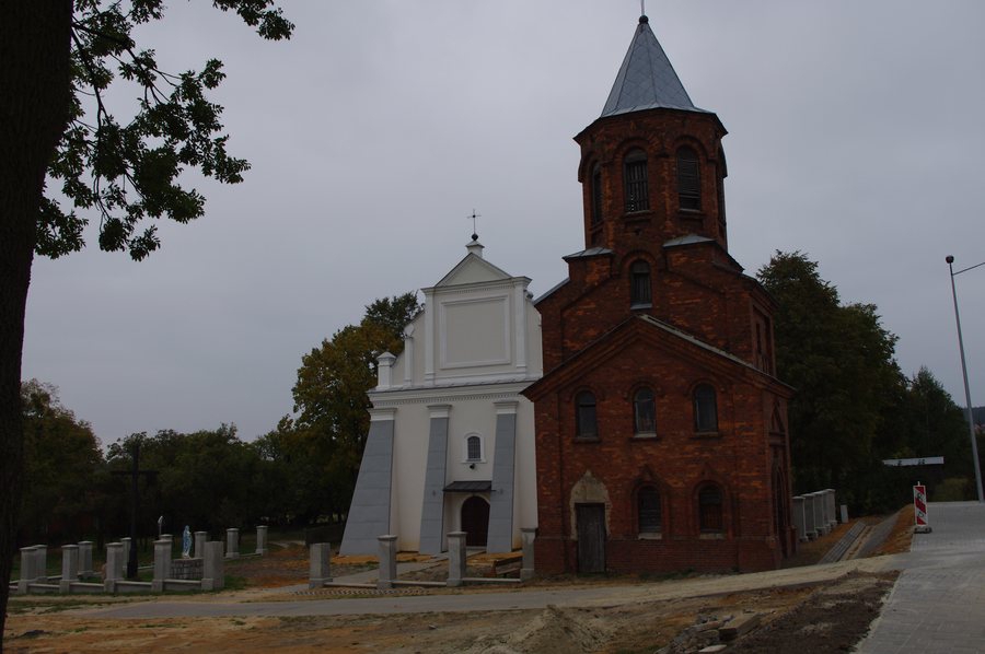 Podgórze - former Orthodox church, now Roman Catholic parish church
Photo: Ar2rek via Source, CC BY-SA 3.0 pl
Chełmski at a glance
- The Chełmski Landscape Park was established in 1983 and covers 16,457 hectares; 4,702 hectares of it lie within the municipality of Chełm.
- Cycling routes in the municipality range from about 8 to 75 kilometres.
- The Stańków Reservoir covers about 40 hectares, while Zalew Staw covers 15 hectares.
- Chełmski County spans the macroregions of Polesie Wołyńskie and Wyżyna Lubelska.
What cycling routes are there in the municipality of Chełm?
The green-marked route “Leśne ostępy Chełmskiego Parku Krajobrazowego” is 19.45 kilometres long. It leads from the northern outskirts of Chełm past the area around the Stańków Reservoir and the Uherka Valley, then through wooded areas near Czułczyce and Sajczyce to Ruda Opalin. Its described course therefore brings together several distinct landscape impressions.
Other routes differ mainly in length and theme: the blue cycle route “GMINA CHEŁM – wpisane w krajobraz, wpisane w historię” is 75 kilometres long and leads to places in the municipality associated with history, nature, recreation and leisure. “Uroki Sobowickie” is an 18-kilometre route marked in red, while “Pagóry Janowskie” covers about 8 kilometres. These figures help compare route lengths, but do not indicate how long a walk or ride will take. Markings and conditions may vary, so it is worth checking the current signage before setting off by bike.
Which bodies of water and recreational activities are in the spotlight?
The artificial Stańków Reservoir covers about 40 hectares and is around 4 metres deep; its bottom is muddy. Because water flows in from the Uherka, it is also called Zalew na Uherce. Numerous rare and protected waterbird species and the European pond turtle are found there. Breeding by 152 bird species has also been recorded in the Chełmski Landscape Park.
At Zalew Żółtańce, a causeway leads to a supervised bathing area and a designated fishing area. The site has a beach, piers, benches, covered tables, barbecue and fire pits, sports courts, a playground and an outdoor fitness area. The “Południowe barwy krajobrazu Gminy Chełm” cycling route also follows the Uherka through Pokrówka, Żółtańce and Żółtańce Kolonia; the entire route offers scenic views and is designed for recreation. At Zalew Żółtańce, additional facilities along this route also include a playground, a pier and a toilet for people with disabilities. A bus stop is about 20 metres from the beach. Check current services before travelling; seasonal operating conditions at the bathing area may change.
Zalew Staw offers a different point of comparison: this 15-hectare body of water is described as a fishing area and provides easy access to the water. There is a large car park at the bathing area, and facilities also include two piers, covered benches and a playground. The recreational and fishing opportunities described for the two bodies of water can therefore be compared.
Which historic buildings define the municipality?
Stołpie is home to a stone tower dating from the 12th century. The Roman Catholic parish church of Christ the Saviour in Podgórze was originally an Orthodox church and is mentioned in historical sources, together with an Orthodox monastery, from 1440. Srebrzyszcze is home to a Baroque palace dating from the 17th century. It was founded by Józef Łopuski, the sword-bearer of Chełm, and is surrounded by a park laid out in the style of an Italian garden.
What landscapes are found in the wider county area?
Chełmski County includes parts of Polesie Wołyńskie and Wyżyna Lubelska. Landscapes in the wider county area include the gentle hills of Pagóry Chełmskie, which reach up to 300 metres above sea level and consist of chalk marls and sandstones. These details provide a broader landscape context, while the cycling routes and bodies of water mentioned above are described within the municipality.
Natural areas also offer different themes for planning a trip. The Serniawy nature reserve protects riparian alder and ash forest as well as low-growing oak-hornbeam forest. It is home to numerous pedunculate oaks around 200 years old and black alders over 100 years old. The fully protected plant species dziewięćsił popłocholistny grows in the Stawska Góra nature reserve; four occurrences of this species are known in Poland. A 4.5-kilometre educational trail lets visitors explore the Bachus nature reserve. These three examples are located across the wider area of Chełmski County, not at a single excursion site.
When looking for a hotel, you can match the interests described here to your own travel plans: cycling routes, bodies of water and cultural attractions offer different focuses. This gives you a clearer idea of what you would like your stay to include as you begin your accommodation search.
Discover more destinations: Gotówka, Chełm, Huta, Stańków, Brzeźno, Nowosiółki-Kolonia, Czarnołozy, Dorohusk, Rejowiec, Romanówka and Stołpie.
FAQ
How do the cycling routes in the municipality of Chełm differ?
The routes listed are about 8 kilometres (“Pagóry Janowskie”), 18 kilometres (“Uroki Sobowickie”), 19.45 kilometres (“Leśne ostępy Chełmskiego Parku Krajobrazowego”) and 75 kilometres (“GMINA CHEŁM – wpisane w krajobraz, wpisane w historię”) long. Their lengths allow a direct comparison, but do not indicate how long the rides will take.
What does Zalew Żółtańce offer?
Facilities listed include a beach, piers, seating and barbecue areas, sports courts, a playground and an outdoor fitness area. A causeway leads to the supervised bathing area and designated fishing area. Check seasonal operating conditions before visiting.
How do the Stańków Reservoir and Zalew Staw differ?
The Stańków Reservoir covers about 40 hectares and is around 4 metres deep; its muddy bottom and the presence of protected waterbird species and the European pond turtle give it a natural character. The 15-hectare Zalew Staw is described as a fishing area and has, among other facilities, two piers, covered benches and a playground.
Which historic buildings are described in the municipality?
Stołpie is home to the stone tower dating from the 12th century. The church in Podgórze originated as an Orthodox church and has been mentioned in historical sources together with an Orthodox monastery since 1440. In Srebrzyszcze, you can see the 17th-century Baroque palace and its park laid out in the style of an Italian garden.
For the broader travel overview: Lublin.

