
Dobrzyków: Church and Routes
Accommodation in Dobrzyków
Dobrzyków brings together two distinct themes: the Church of the Nativity of the Blessed Virgin Mary, with its rich furnishings, and two routes that either start here or pass through the village.
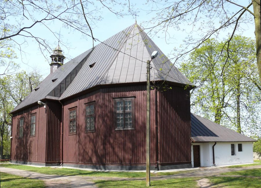 File:Kościół pw. Narodzenia NMP w Dobrzykowie (gm. Gąbin).jpg
Photo: MazowieckiPielgrzym via Wikimedia Commons, CC BY-SA 4.0
Dobrzyków at a glance
Two common ash trees protected as natural monuments stand by the church. A municipal plan adopted in 2008 gives their trunk circumferences as 355 and 360 cm and their height as 25 m each. The yellow Szlak główny Kotliny Płockiej starts in Dobrzyków; the 47.3 km Szlak Środkowej Wisły runs between Wyszogród and Płock along the Vistula River, passing through the village.
What art defines the Church of the Nativity of the Blessed Virgin Mary?
The main altar dates from the 18th century and was transferred to Dobrzyków from the dissolved Norbertine convent in Płock. The rest of the furnishings also include pieces from different periods. The stone baptismal font with a wooden lid dates from the 16th century. Late Gothic figures of the Madonna and Saint John, from the early 16th century, stand at the chancel arch.
Saint Anne with the Virgin and Child is depicted on the curtain of the main altar painting; the work dates from the first half of the 19th century. A late Renaissance hanging chandelier, known as a Meluzyna and shaped like a deer’s head, dates from the late 16th century. Together, the font, figures, paintings, and chandelier show different forms of sacred art and span the period from the early 16th to the 19th century.
The complex also includes structures outside the church: a wooden bell tower stands in front of the church, and a brick chapel from the mid-19th century stands behind it. The church is also a pilgrimage destination and a venue for local indulgence celebrations associated with Marian devotion. If you would like to plan your trip around one of these occasions, check the dates in advance.
Which routes include Dobrzyków?
A municipal plan adopted in 2008 describes the yellow Szlak główny Kotliny Płockiej as starting in Dobrzyków. From there, the route described passes Ciechomickie and Górskie lakes and continues through Grabina, Łąck, Lake Sendeń, Krzywy Kołek, Trzcianno, and Nowy Duninów to Włocławek. Before setting out, check the current trail signs and the condition of the route.
Another route mentioned is the Szlak Środkowej Wisły: the 47.3 km trail runs along the Vistula between Wyszogród and Płock and passes through Dobrzyków. The two descriptions can therefore be distinguished by different features: the yellow route is defined by its starting point in Dobrzyków and its sequence of lakes and villages, while the Szlak Środkowej Wisły is identified by its length, endpoints, and riverside course.
Discover more destinations: Rogozino, Płock, Cierszewo, Cekanowo, Kozłowo, Słupno, Łąck and Maszewo Duże.
FAQ
What is a Meluzyna in the Church of the Nativity of the Blessed Virgin Mary?
It is a late Renaissance hanging chandelier from the late 16th century, shaped like a deer’s head.
What is the religious significance of the church?
It is a pilgrimage destination and a venue for local indulgence celebrations associated with Marian devotion. Check the dates in advance if you are planning to attend a celebration.
How long is the Szlak Środkowej Wisły?
The route is 47.3 km long and runs between Wyszogród and Płock along the Vistula River, passing through Dobrzyków.
For the broader travel overview: Płock.

