
Lipińskie: Discover Cycling Routes and Local History
Accommodation in Lipińskie
In Lipińskie, specific cycling route details meet historical names and traces in the surrounding area. This allows you to understand the place both through its connections to cycling routes and its local history.
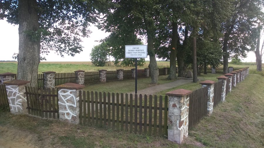 Cmentarz wojenny z I i II wojny światowej w Lipińskich - fot. 1
Photo: Grzegorz Poniatowski via Wikimedia Commons, CC BY 3.0
Lipińskie at a glance
- Founded under Magdeburg rights: 1487.
- Historical names: Lipiensken; Lindenwiese from 1928 to 1945.
- Green-marked route Giżycko–Wydminy–Miłki–Giżycko via Lipińskie: 61 km; the official figure differs, at 71 km.
Which cycling route details are useful for planning?
The green-marked cycling route Giżycko–Wydminy–Miłki–Giżycko passes through Lipińskie. The route is listed as 61 km, which differs from the official figure of 71 km. When assessing this route, keep both figures in mind rather than treating 61 km as the matching official length.
Another green cycling route runs from Miłki via Lipińskie towards Szczepanki and Wydminy. A tourist description dated 2007–2009 lists it as “41 + 20 km.” The two routes differ in their course and in how their lengths are presented. Check the current signage and trail conditions before setting out.
What local history has been recorded?
Lipińskie was founded under Magdeburg rights in 1487. Historically, the place was called Lipiensken; from 1928 to 1945, it was known as Lindenwiese. The founding date and historical names offer different starting points for exploring the place.
The year 1487 belongs to the history of the settlement’s founding. Lindenwiese, by contrast, refers to a specifically defined period in the 20th century, while Lipiensken is another historical name for the place. Those interested in history can consider the founding date and the history of the names separately.
What historical traces are there in the surrounding area?
In the fields between Lipińskie and Lipowy Dwór, ruins of Second World War bunkers can be seen to the right of the road. They are part of the so-called Lötzen Fortified Zone. The location between the two places and its position relative to the road help put this military history in context.
Another historic site is a forgotten Masurian cemetery, about 100 metres beyond the last buildings in Lipińskie. Its location is described in relation to the built-up edge of the village, while the bunker ruins are located in the fields between Lipińskie and Lipowy Dwór. This means that the surrounding area offers two distinct historical points of interest alongside the settlement’s founding and old place names.
Discover more destinations: Wyszowate, Paprotki, Milki, Wydminy, Wilkasy, Bogacko, Marcinowa Wola and Strzelce.
FAQ
What distance figures are given for the cycling route via Lipińskie?
The green-marked Giżycko–Wydminy–Miłki–Giżycko route is listed as 61 km; the official figure is 71 km. Another tourist description from 2007–2009 gives the route from Miłki via Lipińskie towards Szczepanki and Wydminy as “41 + 20 km.”
What historical names did Lipińskie have?
Historically, the place was called Lipiensken. From 1928 to 1945, it was known as Lindenwiese.
Which historic sites are in the surrounding area?
In the fields between Lipińskie and Lipowy Dwór, ruins of Second World War bunkers from the so-called Lötzen Fortified Zone can be seen. A forgotten Masurian cemetery lies about 100 metres beyond the last buildings.
For the broader travel overview: Lötzen.

