
Nawodna
Accommodation in Nawodna
Nawodna combines a distinctive settlement layout with a landscape along the Rurzyca River. This gives you two specific points to consider when planning your trip: the medieval church and historic village fabric on the one hand, and the slope shaped by dry valleys on the other.
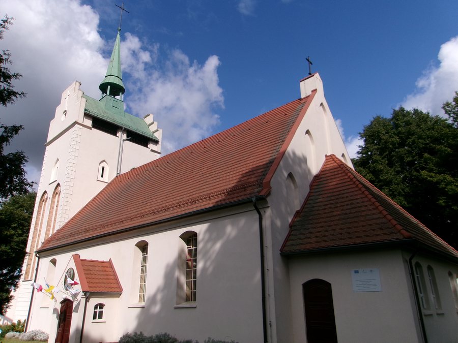
Nawodna at a glance
- Nawodna lies on the Rurzyca River and on county road 1387Z between Chojna and Lisie Pole.
- The historic settlement has an oval layout; the church stands in the center of a central spindle-shaped square.
- The Parish Church of the Holy Cross is a Gothic building from the late Middle Ages. Its tower dates from the turn of the 15th and 16th centuries.
- The slope along the Rurzyca is cut through by numerous dry valleys. Xerothermic grasslands grow on the warm, south-facing slopes of the ravines.
What characterizes the landscape around Nawodna?
The Rurzyca River defines Nawodna's geographical setting. Part of the slope associated with the village is cut through by numerous dry valleys. Xerothermic grasslands grow on the warm, south-facing slopes of the ravines. The term refers to the warmth and dryness of these locations; the distinctive feature described is therefore not just the river, but also the slopes and their vegetation.
If you consider landforms as well as culture when choosing a destination, you can place Nawodna in context through these features: the river, slope, dry valleys, and south-facing ravines make up the natural side of the village's profile.
What story does the village layout tell?
Nawodna is laid out as an oval village. The church stands in the middle of a central, spindle-shaped square. This combination of an oval settlement and central square gives the historic village its distinctive structure. If you are interested in settlement patterns, you can consider the square and the church's position as related features, rather than viewing the village solely through its individual historic buildings.
The Parish Church of the Holy Cross is a Gothic building from the late Middle Ages. The tower is dated more specifically to the turn of the 15th and 16th centuries. The church itself was rebuilt in 1966 after being damaged by a fire in 1964. Several dates are therefore relevant when looking at the building: the church's medieval origins, the dating of the tower, and its reconstruction after the fire.
The churchyard contains other old architectural features: a gate and stone enclosure dating from the 14th or 15th century are among its oldest surviving elements. Another religious building in the village is the Old Lutheran chapel. It was built between 1816 and 1825 and serves as a funeral chapel. The church, churchyard, and chapel thus represent different aspects of the village's history, each with its own date or function.
What should you consider when choosing accommodation and finding your way around?
When choosing where to stay, you can assess Nawodna according to your interest in the historic village layout, ecclesiastical architecture, or the landscape along the Rurzyca. The village's location is described in relation to county road 1387Z between Chojna and Lisie Pole. A PKS bus stop was also designated in Nawodna during the 2016–2022 planning period. This information applies to that planning period. When looking for a hotel or other suitable accommodation, the main consideration is whether Nawodna, with these features, suits your interests as a destination.
For comparison with other destination pages, you can also view Stare Brynki, Kolbatz, Krzywin, Cedynia, Gryfino, Steklno, Widuchowa, and Binowo.
FAQ
Where is Nawodna?
Nawodna lies on the Rurzyca River and on county road 1387Z between Chojna and Lisie Pole.
What is known about the Church of the Holy Cross?
It is a Gothic building from the late Middle Ages. Its tower dates from the turn of the 15th and 16th centuries. After a fire in 1964, the church was rebuilt in 1966.
What is distinctive about the landscape?
Part of the Rurzyca slope is cut through by numerous dry valleys. Xerothermic grasslands grow on the warm, south-facing slopes of the ravines.
For the broader travel overview: Greifenhagen.

