
Municipality of Ston – salt pans, walls and regional cuisine
Accommodation in Municipality of Ston
Salt-making traditions, medieval fortifications and oysters from Mali Ston Bay give the Municipality of Ston a varied character. When planning your trip, the range of options is particularly appealing: you can explore history and regional cuisine, include cycling routes or choose a hike with an elevation gain.
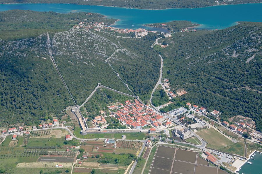 File:Aerial image of Ston (view from the southwest).jpg
Photo: Carsten Steger via Wikimedia Commons, CC BY-SA 4.0
File:Aerial image of Ston (view from the southwest).jpg
Photo: Carsten Steger via Wikimedia Commons, CC BY-SA 4.0
Quick facts about the Municipality of Ston
The historic urban ensemble includes Ston and Mali Ston, the walls connecting them, the Mali Ston Bay Nature Reserve, Stonsko Polje and the salt pans. The fortification system is 5.5 km long in total and comprises the walls of Ston and Mali Ston, the Great Wall, 41 towers and six bastions. Mali Ston oysters have a protected designation of origin from the European Union.
What shapes its history and culture?
Salt production has continued for many years at the salt pans of Ston. The “Vino” educational trail begins at the oldest salt pan in the Mediterranean that is still in operation. Salt-making is therefore not only part of the town’s history, but also a subject you can encounter along this trail.
In Ston, the Lapidarium in the Bishop’s Palace is one of the more significant collections of medieval art in southern Croatia. Exhibits include stone chancel screens, frescoes and ornaments with rich interlace decoration. They illustrate artistic activity in Ston and its immediate surroundings, from Roman antiquity to later historical periods. The Church of St Michael is also a notable historic site: it stands on the hill above Stonsko Polje and contains valuable old frescoes. In Žuljana, the Church of St Roko-Julian is located in the centre of the village.
The fortification system includes various structures, not just a single wall. In Mali Ston, the Koruna Tower consists of four smaller towers. A wall protects the harbour and ends at the cylindrical Toljevac Tower; the pier at Mali Ston dates from 1491. These details add specific architectural features and the harbour area to the overall picture of the complex.
Which routes suit your trip?
For a route you can take on foot or by bicycle, consider Napoleon Road: it runs for 7 km to Ponikve. A separate cycling route runs from Ston through Vino to Prapratno and is about 6 km long. Another route goes from Ston to Kobaš and Marčuleti Bay; it is about 8 km long. The approximate distances refer to each cycling route as described.
The hiking route to Mount Sveti Ivan starts at Žuljana Beach and climbs towards Vučine Bay. It is 6 km long and has an elevation gain of 465 metres. This sets it apart from the cycling routes described, both in its course and its elevation gain. If you are planning a hike, take the stated elevation gain into account when deciding.
What is there to discover in the regional cuisine and on the water?
With their EU designation of origin, Mali Ston oysters are also of interest to travellers keen to discover regional products. Boat trips to oyster farms, including tastings of oysters freshly harvested from the sea, are among the experiences available in the bay. Boat trips also go to oyster and mussel farms.
Wine routes and visits to wineries and vineyards lead from Metohija, Boljenovići and Sparagovići through Putnikovići to Dubrava. In Žuljana, a traditional wine tasting on the beach is part of the programme for the Feast of St Martin on 11 November. For watersports enthusiasts, Žuljana offers diving at attractive dive sites, organised by local dive centres. Kobaš is known as a destination for yacht owners and sailors; Broce has a coastline accessible to yachts and smaller boats.
How do you choose a base and explore the area?
Bus routes connect Ston with several cities in Croatia and some cities in Bosnia and Herzegovina. The D-414 state road runs through Ston and Zamaslina to Zaton Doli, the last settlement in the Municipality of Ston. A ferry runs year-round from Prapratno to the island of Mljet. You can take this transport information into account when choosing how to travel and planning further stops, without treating the different connections as interchangeable.
Stonsko Polje preserves the Roman land division and has numerous small churches and chapels. Together with the salt pans, the two towns of Ston and Mali Ston, and the Mali Ston Bay Nature Reserve, it reflects the municipality’s diverse cultural and landscape features. For information about individual places, see the dedicated pages for Metohija, Mali Ston, Duba Stonska, Hodilje, Zaton Doli, Dančanje, Broce, Ston, Prapratna, Žuljana and Putnikovići.
FAQ
How long is the Ston fortification system?
The system is 5.5 km long and comprises the walls of Ston and Mali Ston, the Great Wall, 41 towers and six bastions.
How long is the hiking route to Mount Sveti Ivan?
The route is 6 km long and has an elevation gain of 465 metres. It starts at Žuljana Beach and climbs towards Vučine Bay.
Is there a ferry connection to Mljet from Prapratno?
Yes. A ferry runs year-round from Prapratno to the island of Mljet.
For the wider travel overview: Peljesac.

.jpg)