
Municipality of Brela: Beach, Nature and Cultural Heritage
Accommodation in Municipality of Brela
The Municipality of Brela combines a pebble beach on a protected headland with nature and cultural attractions on Biokovo. For planning your trip, hiking trails, a cycling route and notable sites offer different points of interest—from the coast to protected cultural heritage.
Key facts about the Municipality of Brela
Punta Rata is a pebble beach on a protected headland, where crystal-clear sea meets a fragrant pine forest. The SV. NIKOLA hiking route is easy and about 6.5 km long; the moderately difficult Transverzala Makarskom rivijerom cycling route runs from Brela to Gradac and is 63.2 km long. Blitvenjak, a traditional cake made with Swiss chard, is also prepared in Brela.
The Francuska cesta, also known as Napoleonova cesta, runs along the slopes of Biokovo at an elevation of 357 to 444 metres above sea level; its gradient is no more than 6 percent. It has been listed as a cultural asset of the Republic of Croatia since 25 September 2017.
What nature experiences do the coast and Biokovo offer?
At Punta Rata, the beach and pine forest come together in the landscape: the pebble beach lies on a protected headland, where crystal-clear sea meets the fragrant forest. If you are particularly interested in coastal scenery when planning your trip, this is a distinctive natural highlight of the municipality.
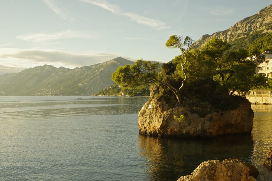
Another natural feature is Kamen Brela. Seven Aleppo pines of different ages and eleven other plant species grow on the small rocky islet. These details also make the islet interesting for visitors curious about vegetation in a distinctive rocky setting. The beach and islet are separate nature attractions; their descriptions do not imply a shared route.
Which routes and activities can you compare?
The easy SV. NIKOLA hiking route starts at Gornji Kričak and passes the Chapel of Sv. Kajo, Nevistina stina and the Church of Sv. Nikola before returning to the starting point. Its length is specified at about 6.5 km.
The TOPIĆI hiking route, also described as easy, follows a different course: it starts at Gornji Kričak, goes via Topići down to Baška Voda, then follows the coast back to Brela. This makes the return along the coast a distinguishing feature compared with the circular route of SV. NIKOLA. No distance is specified for TOPIĆI.
For a cycling trip, the Transverzala Makarskom rivijerom offers a moderately difficult option from Brela to Gradac. Its 63.2 km is the length of this route, not a round trip. In the Penjalište Brela sport climbing area, routes range from easier sections for beginners to more challenging routes of intermediate difficulty. Hiking, cycling and climbing differ here by activity, stated distance or difficulty level.
Which cultural sites and historical features are part of Brela?
At the Brela Gornja Interpretation Centre, the “Biokovo” exhibition presents the underground world of Biokovo Nature Park as well as fossils, zoology, botany and geology. Its broad range of topics makes the exhibition a cultural and natural attraction for visitors keen to learn about more than individual landscape features.
Francuska cesta is also a named part of the cultural heritage: its Croatian name appears alongside the name Napoleonova cesta, and it has been listed as a cultural asset since 25 September 2017. In Gornja Mala in Gornja Brela, the Church of Gospe od Zdravlja has been designated a protected cultural asset since 1988. The Church of Gospe od Karmela, also known as Gospa od Pobjede, is a Baroque church on an enclosed plateau above Soline in Brela. Pine trees surround the plateau. These places differ in their function and form: an exhibition, a listed cultural asset and a Baroque church.
Which regional speciality is associated with Brela?
Blitvenjak is a traditional cake from Brela, made with Swiss chard. If regional cuisine is among your travel interests, Blitvenjak is a specific local way to connect with Brela.
More destination pages in the directory: Municipality of Muć, Gradac, Municipality of Baška Voda, Municipality of Lećevica, Municipality of Podstrana and Municipality of Cista Provo.
FAQ
How long is the SV. NIKOLA hiking route?
The easy route is about 6.5 km long. It starts at Gornji Kričak, passes the Chapel of Sv. Kajo, Nevistina stina and the Church of Sv. Nikola, then returns to Gornji Kričak.
What makes the TOPIĆI route different?
It starts at Gornji Kričak, goes via Topići down to Baška Voda, then follows the coast back to Brela. No distance is specified for the route.
What kind of landscape characterises Punta Rata?
Punta Rata is a pebble beach on a protected headland, where crystal-clear sea meets a fragrant pine forest.
What is Blitvenjak?
Blitvenjak is a traditional cake from Brela, made with Swiss chard.
For the broader travel overview: Split-Dalmatia.

