
Gronków: Church, Rocks and Trails
Accommodation in Gronków
Gronków brings together architectural history and a landscape that extends beyond the built-up area: the Church of the Immaculate Heart of Mary stands in the village, while red limestone rocks lie just outside it. Trails through the surrounding area offer further perspectives for planning your trip. You can explore culture, rocky landscapes and route options as distinct highlights of your stay.
Gronków at a glance
- The built-up area lies at an elevation of 580 to 650 m above sea level.
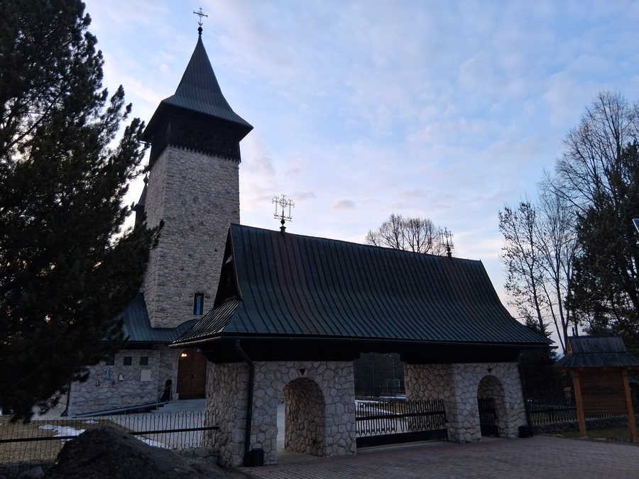
- The Church of the Immaculate Heart of Mary was built in the 18th century as a filial chapel of the parish in Szaflary and became an independent parish in the 20th century.
- Cisowa Skałka rises to 685 m east of the village. Mała Skałka is also known as Grzebieniowa; both rocks lie just outside the village.
- A green hiking trail leads from Szaflary through the Pieniny Spiskie to the castle in Niedzica. The Szlak wokół Tatr runs from Gronków across the gently undulating plain of the Nowotarg Basin.
What shapes the landscape around Gronków?
The elevations provide a brief impression of the surrounding area: the built-up area lies between 580 and 650 m, while Cisowa Skałka reaches 685 m east of the village. The rocks are just outside the village boundary, making them a nearby destination rather than part of the village itself. Mała Skałka is also called Grzebieniowa; this alternative name does not refer to Cisowa Skałka.
The steep red limestone rocks lie among fields and feature natural vegetation. They are a place to relax and offer a viewpoint over the eastern part of Podhale. This landscape is a different point of interest from the church’s local history: here, the focus is on rock formations, vegetation and views. If you are taking stock of Gronków’s scenic highlights, these rocks are a specific point of reference.
Which trails can you explore from Gronków?
The Szlak wokół Tatr runs from Gronków across the gently undulating plain of the Nowotarg Basin. The section between Gronków and Nowa Biała is considered scenic throughout. For trip planning, this describes the character of that section; check current trail conditions before setting out on a specific hike.
A separate route description concerns the green hiking trail at the foot of the nearby ascent. It leads from Szaflary through the Pieniny Spiskie to the castle in Niedzica. The trails mentioned can be distinguished by their different reference points: the Szlak wokół Tatr is associated with Gronków, the basin and the section to Nowa Biała; the green hiking trail with Szaflary, the Pieniny Spiskie and Niedzica. This lets you understand the routes by their course without combining them into a single trail.
What does the church tell us about the village?
The Church of the Immaculate Heart of Mary connects an architectural history dating back to the 18th century with a later change in its ecclesiastical role: it was originally built as a filial chapel of the parish in Szaflary and became an independent parish in the 20th century. This sequence makes it a tangible reference point for the village’s history.
Its construction also contributes to its significance. The church is an example of Podhale’s sacred architecture and was built using log construction without nails. It has been expanded and renovated several times while retaining its original character. Taken together, its design and changes over time offer a more nuanced picture: its history is not defined by just one phase of construction, but also by the combination of the original structure and later alterations.
Discover more destinations: Łopuszna, Obidowa, Nowy Targ, Czorsztyn, Podwilk, Trybsz, Maruszyna, Bańska Niżna.
FAQ
What is special about the church in Gronków?
It was built in the 18th century as a filial chapel of the parish in Szaflary, later became an independent parish, and was constructed using log construction without nails. It has retained its original character despite several expansions and renovations.
Where are Cisowa Skałka and Mała Skałka?
Both rocks lie just outside the village. Cisowa Skałka is east of Gronków at an elevation of 685 m; Mała Skałka is also known as Grzebieniowa.
Which trails are associated with Gronków?
The Szlak wokół Tatr crosses the gently undulating plain of the Nowotarg Basin; its section between Gronków and Nowa Biała is considered scenic. The green hiking trail runs from Szaflary through the Pieniny Spiskie to the castle in Niedzica. Check current trail conditions before setting out on a specific hike.
For the broader travel overview: Nowotarski.

