
Szlembark on the Lubań Range
Accommodation in Szlembark
Szlembark lies on the southern slopes of the Lubań Range, which forms the eastern ridge of the Gorce Mountains.
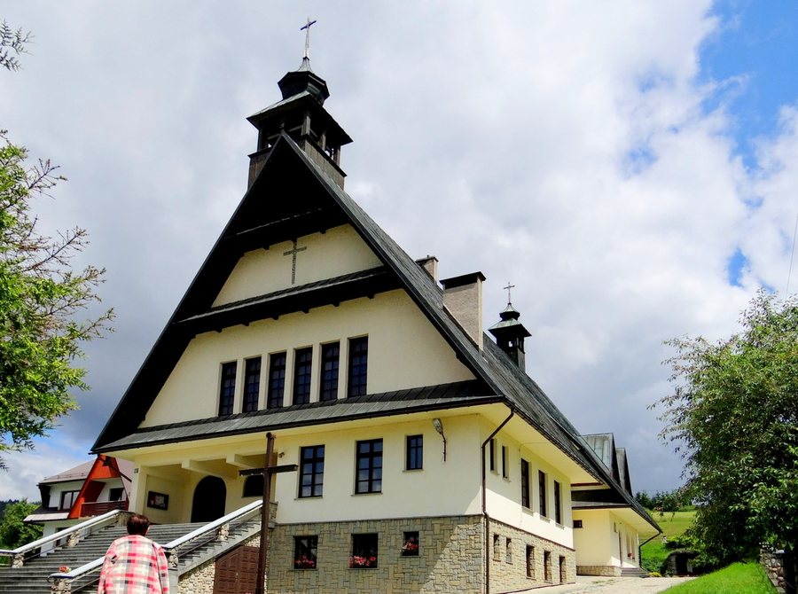 Szlembark. Kościół Niepokalanego Serca Pana Jezusa
Photo: Gorofil via Wikimedia Commons, CC BY-SA 4.0
Szlembark. Kościół Niepokalanego Serca Pana Jezusa
Photo: Gorofil via Wikimedia Commons, CC BY-SA 4.0
Szlembark at a glance
- Szlembark lies on the southern slopes of the Lubań Range in the Gorce Mountains.
- The hamlet of Studzianki is located on the main ridge near the border with Ochotnica and is considered a place to stay for a nature getaway.
- The Spiš Loop is a 62.3-kilometre hiking and cycling loop in the Polish-Slovak border region, rated as difficult.
What kind of landscape characterizes Szlembark?
Its location on the southern slopes of the Lubań Range places Szlembark on the eastern ridge of the Gorce Mountains. This provides a specific starting point for understanding the character of the place: the focus here is on the mountain landscape, not an urban or coastal setting. If you are looking for accommodation for a nature-focused stay, you can first consider Szlembark in terms of its landscape and address the question of individual excursions separately.
Szlembark offers views of the Tatras and the Gorce Mountains.
What accommodation options does Studzianki offer?
Studzianki is a hamlet on the main ridge near the border with Ochotnica. It is considered a place to stay for tourists and holidaymakers seeking a nature getaway. Studzianki is therefore a distinct reference point if you want to consider the location of accommodation within the area.
For planning purposes, it helps to treat the location and leisure routes as two separate questions. Studzianki provides a sense of place within the area described; regional route information, by contrast, helps you assess the types and scope of possible trips. This makes it possible to first determine whether your search is more focused on the landscape around your place of stay or on a particular activity in the surrounding area.
How should you assess the Spiš Loop?
The Spiš Loop is an international hiking and cycling route in the form of a loop along the Polish-Slovak border region. It is 62.3 kilometres long and rated as difficult. Elevation changes and sections requiring a mountain bike contribute to its difficulty.
A branch leads via Dursztyn to Studzionki. There, the route connects with VeloDunajec, the Trail Around the Tatra Mountains and the Enclave of Active Leisure in the Gorce Mountains.
Which cycling route heads towards Szlembark?
Another route option is a cycling tour that starts at the STARTVELO.PL rental shop for electric and conventional bicycles and heads towards Szlembark. The rental shop has a large car park.
When comparing the two, keep their different planning considerations in mind. For the Spiš Loop, the length of 62.3 kilometres and its difficult rating help you assess the route; for the other cycling tour, the starting point at the rental shop and the direction of travel are the specific reference points. This helps you decide which type of route information matters most for your travel plans without treating the two tours as the same.
Discover more destinations: Rokiciny Podhalańskie, Grywałd, Szczawnica, Ponice, Niedzica, Piekielnik, Trybsz, Waksmund.
FAQ
Where is Szlembark?
Szlembark lies on the southern slopes of the Lubań Range, which forms the eastern ridge of the Gorce Mountains.
What is known about accommodation in Studzianki?
The hamlet on the main ridge near the border with Ochotnica is considered a place to stay for tourists and holidaymakers seeking a nature getaway.
What are the features of the Spiš Loop?
The international hiking and cycling loop in the Polish-Slovak border region is 62.3 kilometres long and rated as difficult. A branch leads via Dursztyn to Studzionki and connects with several other routes.
Go to the broader travel overview: Nowotarski.

