
Discover Sieniawa Żarska: Townscape and History
Accommodation in Sieniawa Żarska
Discover Sieniawa Żarska through its historic street layout and several well-documented buildings. This gives you concrete starting points for planning your trip, whether you are particularly interested in settlement patterns, church architecture, or historic houses.
Key facts about Sieniawa Żarska
The historic street plan has several distinct directions: a main street runs from east to west, with a second parallel street to its east. A third crosses the town center at right angles from north to south and leads to the railway station in the south.
The documented buildings include the Gothic Church of St. Peter and Paul, a former rectory dating from 1737, and two 18th-century timber-built houses. A section of a cycling route through Sieniawa Żarska was created in 2014.
How is the historic townscape laid out?
The street plan can be understood through three clearly distinguishable lines: the main street forms the east–west axis, while the second street runs parallel to it farther east. The third street crosses the town center from north to south and leads to the railway station in the south. The plan therefore describes not just a single street, but also how the parallel and intersecting axes relate to one another.
These directions provide a helpful framework for understanding the town’s historic layout. If you are mainly interested in historic town structures, this spatial description offers a perspective alongside the individual architectural details.
What does the Church of St. Peter and Paul reveal about its history?
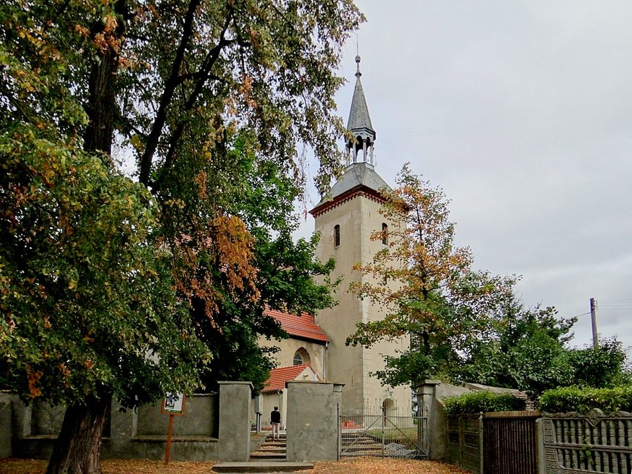
The Gothic church was built in the 14th century and remodeled in the early 16th century. Its tower was added in 1809, followed by the spire in 1867. These dates reveal several phases in the building’s history rather than reducing it to a single period of construction.
The building’s form also offers specific points of reference: it is a single-nave structure built of stone. The rectangular chancel has a late Gothic net vault; the tower adjoins it on the south, and the sacristy on the north. “Single-nave” here means a church space with one main nave. Together with the shape of the chancel and its vault, this gives a more precise picture of the architecture without overlooking the later additions to the tower in the context of the building’s earlier history.
How do the other historic houses differ?
The former rectory is a single-storey brick building dating from 1737, extended in the 20th century. The two 18th-century houses have a different architectural character: they are built using the log construction method and were partially underpinned in the 19th century. Underpinning refers to the subsequent structural reinforcement or strengthening of the lower part of a building.
Different construction methods and traces of different periods can therefore be seen side by side: brick construction and a later extension at the former rectory, and log construction with partial underpinning at the houses. Visitors comparing historic buildings can use materials, construction dates, and documented later changes as points of reference.
What is known about the cycling route section?
In 2014, a cycling route section was created through Świbna, Łukawy, Lubanice, Drożków, Grabik, Sieniawa Żarska, and Miłowice.
Cycling is therefore another option to consider when choosing what to explore, alongside the townscape and architecture.
Discover more destinations: Chlebice, Lipinki Łużyckie, Żary, Lubsko, Łęknica, Dobrzyń, Dluzek and Czaple.
FAQ
How does the historic street plan run?
A main street runs from east to west. A parallel street lies to its east; a third crosses the town center from north to south and leads to the railway station in the south.
What are the distinctive features of the Church of St. Peter and Paul?
The Gothic, single-nave stone church was built in the 14th century and later remodeled. The rectangular chancel has a late Gothic net vault; the tower and spire were added in 1809 and 1867, respectively.
What cycling route information relates to Sieniawa Żarska?
A section created in 2014 ran through Sieniawa Żarska, as well as Świbna, Łukawy, Lubanice, Drożków, Grabik, and Miłowice, in the route sequence listed.
For the broader travel overview: Sorau.

