
Hlubočky: Hotels and Accommodation
Accommodation in Hlubočky
Natural Areas
The Údolí Bystřice Protected Area covers the cadastral area of Hlubočky and extends over 751 hectares in the Bystřice Valley between Smilovský mlýn and Hlubočky. It consists predominantly of well-preserved species-rich and acidophilous beech forests, with small areas of ravine forests, oak-hornbeam forests and dry acidophilous oak forests in the south, as well as remnants of mesic and wet meadows in the river floodplain.
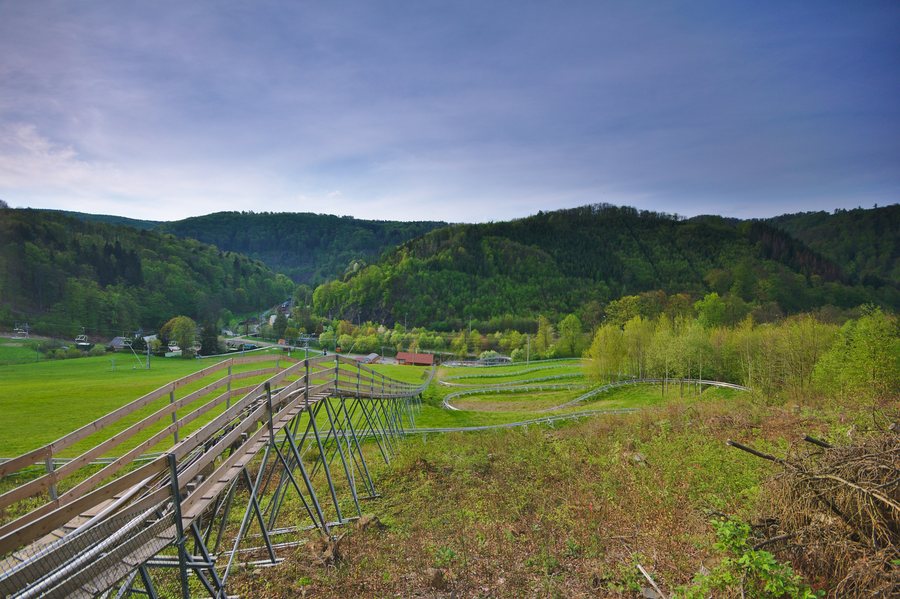 File:Bobová dráha, Hrubá Voda, Hlubočky, okres Olomouc.jpg
Photo: Jiří Komárek via Wikimedia Commons, CC BY-SA 4.0
File:Bobová dráha, Hrubá Voda, Hlubočky, okres Olomouc.jpg
Photo: Jiří Komárek via Wikimedia Commons, CC BY-SA 4.0
The Hrubovodské sutě Nature Reserve is located on the slopes along the right bank of the Bystřice near Hrubá Voda, a district of Hlubočky. It protects a geomorphologically diverse area with natural and near-natural forest ecosystems of the 4th and 5th forest vegetation zones, including beech, fir-beech, ravine and riparian ash-alder forests, as well as characteristic, endangered and regionally declining wild plant and free-living animal species.
In the vicinity of Hlubočky are Kluče Hill (Olomouc-Lošov) and the mountains of Skalice and Růžový Kopec. Stráž is a mountain in the vicinity of Hlubočky.
Trails and Activities
The bobsleigh track in Hlubočky has 17 curves, including 10 left-hand curves and 7 right-hand curves, as well as two 360-degree carousels, a 45-metre bridge and a 9-metre tunnel.
The Kamzíkova stezka treetop trail at the Hrubá Voda resort is a system of climbing elements, slides and a rope maze 13 metres above the ground, suitable for children and adults. The educational trail of the goblin Hrubík is over 1 kilometre long and offers seven educational and entertaining stations for families with children.
The Údolím Bystřice educational trail is a 13-kilometre-long blue-marked route between the Domašov nad Bystřicí and Hrubá Voda railway stations. It is not a loop trail and includes 11 stations covering the nature, geology and history of the landscape along the Bystřice River in the deeply incised valley of the Nízký Jeseník.
Čechovy sady is a park in the vicinity of Hlubočky.
Culture and History
The Church of the Filial Church of the Most Sacred Heart of Jesus is located in the village square of Hlubočky near Školní Street. The Chapel of Our Lady of Sorrows is located in Mariánské Údolí near the Moravia plant.
The first surviving written record of Hluboký Castle dates from 1351. Hluboký Castle lies in the valley of the Bystřice River between the Hrubá Voda and Hrubá Voda–zastávka railway stations, in the cadastral area of the municipality of Hlubočky. The noble residence was built on a rocky, tongue-shaped spur, around which the river flows on three sides.
In the vicinity of Hlubočky are the church buildings Kostel Panny Marie Sněžné and Kostel sv. Michala. Vildštejn is a castle ruin in the wider regional area around Hlubočky.
Transport
Hlubočky railway station is located on line 310 Olomouc–Opava and on the Rýmařov–Valšov connection.
Other Locality Pages
Other locality pages: Zadni Ujezd, Pňovice, Štarnov, Olbramice, Želechovice, Šternberk, Mrsklesy, Bystrovany.
To the higher-level travel overview: Olomouc District.

