
The Dnieper in Ukraine: River Landscapes, Cities and History
The Dnieper, called Dnipro in Ukrainian, is one of Eastern Europe’s defining rivers. It crosses vast landscapes, connects major cities and, with its reservoirs, banks and tributaries, forms a geographical whole that extends far beyond individual viewpoints. The river’s course and significance can be understood through the changing landscapes, cities and stretches of water along its way.
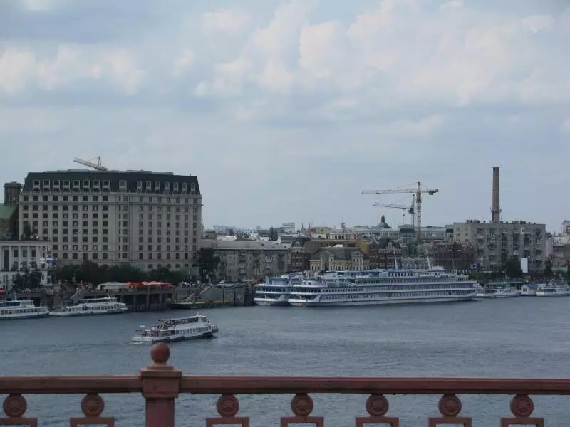 Blick auf den Dnepr mit Ausflugsschiffen und der Uferbebauung einer ukrainischen Stadt.
Photo: Ilya Kiev
Dnieper at a glance
- The Dnieper is one of Europe’s major rivers and flows through Ukraine, Belarus and Russia.
- Kyiv, Cherkasy, Zaporizhzhia and Kherson represent distinct river and urban landscapes.
- Reservoirs widen the river into large bodies of water at several points.
- Banks, islands, port areas and historic sites are not equally accessible everywhere.
- The Kakhovka Reservoir has largely disappeared since the dam was destroyed in 2023; the area is transforming into woodland and small lakes.
- The airspace is closed.
Course and landscape
The Dnieper connects northern forest and lowland regions with central Ukraine and the southern steppe. Its character changes along the way: narrower stretches of river, broad reservoirs, islands, port facilities and open banks give way to one another. Anyone considering the Dnieper as a travel destination should distinguish between river geography, visiting cities and actually spending time by the water. Not every place along the river automatically has a freely accessible riverside path.
The dams and reservoirs have changed the landscape, water management and settlements. The destruction of the Kakhovka Dam on June 6, 2023, was particularly devastating. Three years later, Ukraine’s State Water Resources Agency described the former reservoir as a new landscape of dense woodland and a network of small lakes; the broad expanse of water that once occupied the area is gone. Other stretches of the river and other reservoirs are very different.
Cities on the Dnieper
Kyiv is the main urban reference point, combining riverbanks, history and big-city infrastructure. Farther south, Dnipro and Ukraine at a glance provide a regional perspective. Kherson represents the southern river region near the Black Sea. Odesa is not on the Dnieper, but can be added as a separate Black Sea destination.
The Ukrainian Carpathians are a mountainous region in western Ukraine. In Zaporizhzhia, the river region also evokes industrial history, energy supply and the region’s particular importance. The western and central regions should be distinguished from the southern stretches of the river: Dnipro lies on the river’s middle course, while Kherson is in the south, near the Black Sea.
River cities as individual stops
Kyiv, Dnipro, Cherkasy, Zaporizhzhia and Kherson lie along different stretches of the river, each offering its own urban perspective. When choosing accommodation in Ukraine, proximity to your city destination matters; the accommodation guide explains what to look for. Belarus and Russia also lie along the river; the overviews of Belarus and Russia, as well as Croatia, cover other river and coastal regions.
The river flows through Russia, Belarus and Ukraine; border and security conditions vary from country to country.
Enjoying nature and riverbanks responsibly
Riverbanks are habitats for birds, fish and floodplain vegetation. Away from marked paths, there may be steep banks, private property, construction sites or hazardous areas. Avoid littering, lighting fires and entering sensitive riverside areas. If taking photographs, respect barriers and avoid images that could pose a security concern. In hot weather, carry water and sun protection, and allow extra time for the return journey; adjust your plans along the river if there is flooding or severe weather.
Safety and current conditions
The airspace is closed, and entry and exit are possible only by land. Nighttime curfews may change at short notice. Ukrainian men aged 23 to 60 are generally prohibited from leaving the country, even if they hold another nationality.
Kyiv, Dnipro and Kherson represent different stretches of the river. Odesa is on the Black Sea and can be added as a separate coastal destination. The western Ukrainian landscape and Ukraine overview help put them in perspective.
The comparisons with Belarus, Russia and Croatia concern other river and coastal regions; their border rules differ. Ukraine’s rail services continue to operate, but are affected by disruptions and diversions. Damage and checkpoints slow road traffic; electricity and water supplies may also be interrupted away from the front. The currency is the hryvnia, and cash withdrawals and card payments are possible in many places.
Frequently asked questions about the Dnieper
Which cities lie on the Dnieper?
Kyiv, Dnipro, Cherkasy, Zaporizhzhia and Kherson are among the major Ukrainian cities on the river. Dnipro and Cherkasy lie along its middle course, while Kherson is in the southern section near the Black Sea.
How is the water supply being restored after the dam’s destruction?
New main water pipelines are supplying communities whose water services had previously been disrupted.
Can you travel the Dnieper as one continuous route?
Geographically, the river connects many regions, but in practice, transport links, access, security conditions and distances vary considerably. Each leg must be planned separately.
Entry and exit are possible only by land.
What makes the river interesting as a landscape?
The changing banks, reservoirs, islands, floodplains and cities reveal a wide variety of landscapes. Not every section is publicly accessible or suitable for tourism.
