
Tamgaly, Kazakhstan: Petroglyphs and Cultural Landscape
Tamgaly is located in the Chu-Ili Mountains, about 170 kilometres northwest of Almaty. The UNESCO World Heritage site includes around 5,200 rock carvings and associated archaeological sites. The museum-reserve provides access to the main area along a guided route from a Late Bronze Age burial ground to groups of petroglyphs.
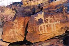 Petroglyph bei Tamgaly
Quick facts about the Tamgaly petroglyphs
- The heritage site lies in the Tanbaly tract of the Chu-Ili Mountains, about 4 km northwest of Karabastau and 170 km northwest of Almaty.
- The Institute of Archaeology has documented around 5,200 images.
- Most of the rock art dates to the Bronze Age; other depictions range from the Saka period to the Middle Ages and modern times.
- The World Heritage Committee added Tamgaly to the UNESCO World Heritage List in 2004.
- Specialist guides or staff accompany visitors along the main museum-reserve route.
Petroglyphs, motifs and dating
The rock-art site features sun-headed figures and priests, people in costume, warriors, couples, women giving birth, and hunting and sacrificial scenes with people and animals. Sun symbols are common; chariots and so-called divine footprints are rare. Archaeological research has documented around 5,200 depictions, set within a landscape of settlements, graves, altars and quarries.
Most of the images are attributed to the Bronze Age. Individual motifs in the Saka animal style, medieval rock art and modern inscriptions add to the ensemble. The densest concentrations of images and possible places of worship are found in the central ravine. Tamgaly was inscribed by UNESCO in 2004; the protected area encompasses the entire archaeological landscape.
The carvings are etched into rock surfaces and form part of their original setting. Staying on the designated visitor paths, observing barriers, and refraining from touching or tracing the images helps protect these fragile originals.
Planning a trip from Almaty
Tamgaly is often planned as a day trip from Almaty. Before setting off, note your starting point, travel time, vehicle or transfer, food arrangements and return journey. An early start can be pleasant in warm weather, but allow enough daylight for the return trip.
Plan your route and transport with enough time for the return journey. Keep a complete address, offline maps, water and a way to be contacted readily available as part of your travel preparations. For money and payments on the way, it is useful to have a second payment option.
Weather, clothing and protecting the rock art
In summer, heat, sun and dry paths can make a visit tiring. Water, a hat, sun protection, sturdy shoes and a break in the shade are especially important. In spring and autumn, wind, rain or changing temperatures can affect the paths. In winter, cold, snow and short days limit the time spent outdoors.
Allow a realistic amount of time at each site so there is enough room for looking around, taking breaks and making the return journey.
Postpone your walk in the event of a thunderstorm, strong winds or impassable paths. Treat these historic traces with care: do not enter restricted areas, and do not highlight the rock art with chalk, water or other means.
For international travellers, the current entry and document requirements remain essential. If combining Tamgaly with other regions, plan the return journey not just by distance, but also around available services, daylight and the next overnight stop.
Combining Tamgaly with other destinations in Kazakhstan
Tamgaly complements a trip that brings together city life, mountains and cultural history. Medeo near Almaty is a mountain and sports destination with a different pace for the day. Turkestan, Otrar and Taraz lie along a route focused more on southern Kazakhstan and are best planned as separate legs of a trip.
Tamgaly is in Kazakhstan, a country in Central Asia. A trip combined with Bishkek or Issyk-Kul involves additional border crossings and driving.
Guided visitor route and directions
The museum-reserve takes visitors around with specialist guides or staff. The main route begins at a Late Bronze Age burial ground on the foothill plain. It then passes through the central area, starting at Petroglyph Group II and including the Late Bronze Age Tanbaly-II burial ground. Group VI lies outside this main route.
The official location is Karabastau, in the Matibulak rural district, Zhambyl District, Almaty Region. The reserve lies about four kilometres northwest of the village and around 170 kilometres northwest of Almaty. For information and guided tours, the reserve lists the phone number +7 777 636 80 05 and tanbalymuseum@mail.ru.
Choose your accommodation for a multi-day stay based on the routes between Tamgaly and Almaty.
Frequently asked questions about Tamgaly
What motifs can be seen at Tamgaly?
Documented motifs include sun-headed figures, animals, hunting and sacrificial scenes, warriors, couples and praying figures. The Institute of Archaeology attributes the depictions to around 50 sites.
What periods do the rock carvings date from?
Most of the images date to the Bronze Age. They are joined by Saka animal-style depictions, as well as medieval and modern rock art and inscriptions.
What is the main route like?
A guided tour begins at a Late Bronze Age burial ground, continues to the central petroglyph zone from Group II, and then proceeds to the Tanbaly-II burial ground. Group VI is not part of this main route.
Where is the museum-reserve located?
Its official location is Karabastau, in Zhambyl District, Almaty Region. The museum lists +7 777 636 80 05 for enquiries.
When did Tamgaly become a UNESCO World Heritage site?
The World Heritage Committee added the archaeological landscape to the World Heritage List in 2004.
