
Marița: Churches and Hiking Trail
Accommodation in Marița
Discover Marița through two distinct themes: its religious heritage and a described hike to Muntele Zăvidanu. The wooden church was built between 1556 and 1557; the hiking trail starts in the village at an altitude of 580 meters. Both the distinctive cultural connections and the estimated duration and changing trail conditions are useful to know when planning your trip.
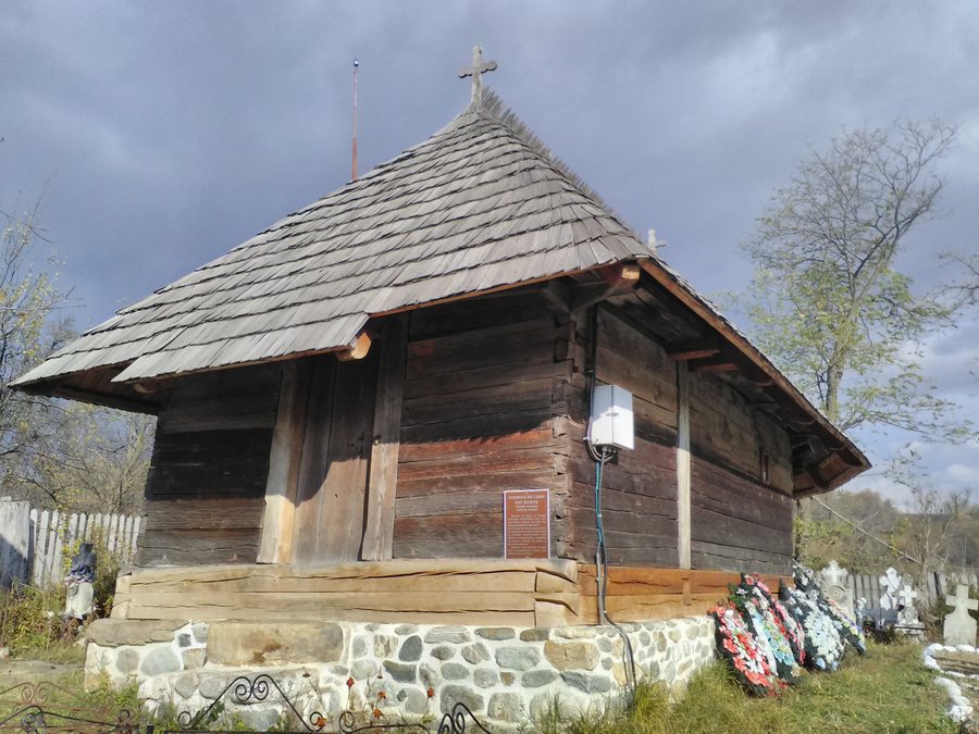 File:Biserica de lemn sat Marita, comuna Vaideeni, jud Rm Valcea.jpg
Photo: Dependablero via Wikimedia Commons, CC BY-SA 4.0
Marița at a glance
- The wooden church of Cuvioasa Parascheva, Sf. Nicolae și Sf. Apostoli was built between 1556 and 1557.
- Marița is home to the parish church “Înălțarea Domnului.”
- The hiking trail to Muntele Zăvidanu starts in Marița at 580 meters and is marked with a yellow dot.
- The route passes through Valea Mariței, Vf. Stânișoara, and Stâna Zăvidanu.
- The hike is estimated to take five to six hours, depending on walking pace and weather.
What churches and cultural connections are there in Marița?
The construction dates of the wooden church of Cuvioasa Parascheva, Sf. Nicolae și Sf. Apostoli are clearly established: it was built between 1556 and 1557. Marița is also home to the parish church “Înălțarea Domnului.” For travelers interested in religious heritage, these are two named points of interest in the village.
Another cultural connection is the cemetery around the wooden church. The rare burial custom of erecting grave posts is preserved there. The construction dates and burial tradition draw attention to different aspects of local culture: the history of a church building and a distinctive cemetery custom.
The church in the cemetery at Marița is occasionally unlocked for researchers or tourists who wish to visit. Occasional access is not a firm promise that it will be open at a particular time. If you plan to visit, arrange your visit locally in advance.
What should you know about the hiking trail to Muntele Zăvidanu?
The trail starts in Marița at an altitude of 580 meters and is marked with a yellow dot. This elevation refers to the starting point. The route passes through Valea Mariței, Vf. Stânișoara, and Stâna Zăvidanu; these names provide specific landmarks for the hike described.
The estimated duration is five to six hours, depending on walking pace and weather conditions. Use this range to plan your time rather than assuming a fixed duration. As trail markings can change and route information should be checked locally, ask about current conditions before setting out.
What regional information adds to the picture of Marița?
The commune of Vaideeni also provides a broader context for trip planning: ten marked hiking trails and two off-road routes for four-wheel-drive vehicles start there, connecting Oltenia at the foot of the mountains with the Lotru Valley. This information about the commune complements the specific details of the trail from Marița to Muntele Zăvidanu.
Another regional name is used for the road from Horezu to Vaideeni, known locally as Drumul Oierilor. This is a road name, while the trail to Muntele Zăvidanu is described by its own starting point, marker, and waypoints.
Discover more destinations: Gura Văii, Banesti, Obârşia Lotrului, Voineasa, Ocnele Mari, Horezu, Pietrișu, Perişani.
FAQ
Where does the hiking trail to Muntele Zăvidanu start?
The trail starts in Marița at an altitude of 580 meters and is marked with a yellow dot. Check the trail marking locally before setting out.
How long does the hike take?
Depending on walking pace and weather conditions, it is estimated to take five to six hours.
Can the church in the cemetery be visited?
It is occasionally unlocked for researchers or tourists. Arrange a planned visit locally in advance.
For the broader travel overview: Vâlcea.

